
 United Kingdom
 France
 Germany
 Netherlands
 Sweden
 USA
USA
 Italy
Italy
 Spain
Spain
More From Contributor


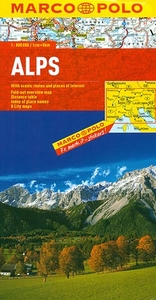
Alps Marco Polo Map
The Alpine areas of Europe on a large overview road map at 1:800, 000 from Marco Polo Travel Publishing with special features to aid navigation and a 64-page index booklet listing locations and geographical features, plus providing information mountain passes. Cartography is from the renowned German publishers MairDumont.A fold-out extension of the map cover gives at-a-glance overview of the whole area covered by the map with the adjoining regions, highlighting main places of interest and making it much easier to find various localities on the main map and/or plan a route. A set of seven peel-on/peel-off stickers, removable without damaging the map, is provided to make routes or locations more prominent when navigating.Coverage extends from the Rhône and Dijon to Vienna and Zagreb,
and from Stuttgart to Tuscany and Umbria. Relief shading with spot heights and plenty of names of individual mountain chains, valleys, etc. shows the topography. Road network indicates toll barriers, motorway services, seasonal closures, roads restricted to or not recommended for caravans, steep gradients, scenic routes, etc. Towns and villages worth visiting and interesting natural features are prominently highlighted. Latitude and longitude grid is drawn at 30’ intervals. Multilingual map legend includes English.The map includes a 64-page booklet attached to its cover listing localities with postcodes, as well as geographical features such as mountains or rivers, plus places of interest. The booklet provides a comprehensive list of mountain passes indicating opening months,
height and gradient, tolls and suitability for caravans. Also included is information on driving regulations in the relevant countries.

Product Description
Reviews/Comments
Add New
Intelligent Comparison
Archived Product

USA Marco Polo Map Stanfords
£6.99
Archived Product

Austria Marco Polo Map Stanfords
£6.99
Archived Product

Egypt Marco Polo Map Stanfords
£4.99
Archived Product

USA East Marco Polo Map Stanfords
£6.99
Archived Product
USA West Marco Polo Map Stanfords
£6.99
Archived Product

Europe Marco Polo Map Stanfords
£6.99
Archived Product

Tunisia Marco Polo Map Stanfords
£5.99
Archived Product

Florida Marco Polo Map Stanfords
£6.99
Vouchers
No voucher codes found.
Do you know a voucher code for this product or supplier? Add it to Insights for others to use.
Do you know a voucher code for this product or supplier? Add it to Insights for others to use.
 Denmark