More From Contributor

£21.99
A 1000-km long mountain bike trail in the very heart of the Austrian Alps in a 172-page German language guide from Verlag Esterbauer. The route, which can be divided into shorter circuits, takes in many of the region’s top tourist destinations including Innsbruck, Kitzbühel, Mayrhofen, Kufstein, Landeck, Ischgl, St. Anton, etc. IMPORTANT
- PLEASE NOTE BEFORE ORDERING
- ALL THE TEXT IN THIS TITLE IS GERMAN ONLY. MAP LEGEND

Includes::
ENGLISH (please see our sample image) & the information provided on the maps is sufficient to use this title without any knowledge of German. Detailed maps at 1:35, 000 show the route & its variants & extensive information is conveyed by symbols indicating road surface, campsites & other accommodation, repair workshops, recreational facilities, places of interest, etc. In addition to gradient markings along the route, the base map has contours at 50m intervals & route profiles are provided for each stage. Descriptions of each stage are accompanied by details of recommended accommodation & cycle repair facilities. All the pages are removable from the ring-binder cover, waterproof & tear-resistant. presented by the Verlag Esterbauer in guide with maps at 1:50, 000 showing the route & its variants. Extensive information is conveyed by symbols, indicating road surface, campsites & other accommodation, repair workshops, recreational facilities, places of interest, etc. A list of various types of accommodation facilities is included.ABOUT THE BIKELINE SERIES: all the titles have been meticulously researched & are highly regarded in their native Germany. Most titles, as indicated in their individual descriptions, also include a separate section listing selected accommodation, from hotels to campsites, youth hostels & rooms in private houses, all with addresses, telephone numbers & price range. Information on towns along each route

Includes::
a list of places of interest, with opening hours, etc. Several of the guides also have street plans. To see the list of other titles in the Bikeline series please click on the series link.


...
Archived Product
£23.99
Map No. 10135, Tysfjord, in the new topographic survey of Norway at 1:50, 000 covering the country on 195 double-sided sheets & first published by Nordeca in 2011
- 2012; fully GPS compatible, indicating waymarked footpaths, campsites, tourist huts, illuminated ski runs, etc. The maps, now published by Nordeca, the successors to Statens Kartverk & its subsequent owners the Ugland Group, are printed on light, waterproof & tear-resistant synthetic paper. Each map covers an area of 62x 45 kilometres (39 x 28 miles approx.), with a 2-km overlap between the sheets. The maps have contours at 20m intervals (10m glacier contours), plus colouring & graphics to show cultivated areas, bogs, forests, etc. In addition to all the information expected of topographic mapping at this scale the maps distinguish between waymarked & unmarked footpaths & show campsites, tourist huts (serviced/self service/no supplies), country hotels & restaurants, & illuminated ski trails. The series uses EUREF89 (WGS84) datum & the maps have a 1-km UTM grid. Map legend is in Norwegian & English. Each title comes in a sturdy protective card envelope.
...
Archived Product
£3.50
Tywyn in 1900 in a fascinating series of reproductions of old Ordnance Survey plans in the Alan Godfrey Editions, ideal for anyone interested in the history of their neighbourhood or family. Features include St Cadvans Church, Gas Works, two schools, the Baptist Chapel, Kings Station & just off College Green the Market Hall. On the reverse is a map to the north of Tywyn which shows the Promenade, Esguan Hall, a good stretch of the Tal-y-llyn Railway with Pen-dre station, etc. About the Alan Godfrey Editions of the 25” OS Series: Selected towns in Great Britain & Ireland are covered by maps showing the extent of urban development in the last decades of the 19th & early 20th century. The plans have been taken from the Ordnance Survey mapping & reprinted at about 15 inches to one mile (1:4, 340). On the reverse most maps have historical notes & many also include extracts from contemporary directories. Most maps cover about one mile (1.6kms) north/south, one & a half miles (2.4kms) across; adjoining sheets can be combined to provide wider coverage.FOR MORE INFORMATION & A COMPLETE LIST OF ALL AVAILABLE TITLES PLEASE CLICK ON THE SERIES LINK. ...
Archived Product
£29.99
Map No. 2330, Tzaneen, in South Africa’s official topographic survey at 1:250, 000 from the country’s national survey organization, the Chief Directorate of Surveys & Mapping. The maps have altitude colouring & contours at 50m or 100m intervals, depending on the map edition, plus spot heights. Deserts, marshes, dry pans, perennial & seasonal water features, etc, as well as protected areas are shown. The maps present the country’s road & rail networks & include the usual information expected on topographic mapping at this scale, although in more rapidly developing areas road information may not necessarily be up to date. Also indicated are magisterial district & provincial boundaries. Latitude & longitude values are shown in the margins at 5` intervals together with South African grid co-ordinates. Typically, each sheet covers an area of one degree of latitude & two degrees of longitude. The projection used is Gauss Conformal. The legend is in English & Afrikaans. ...
Archived Product
£14.95
The Western Fells is part of a planned 8-part Cicerone series of Lakeland Fellranger volumes written by Mark Richards that provide a comprehensive survey of the fells of the English Lake District. This volume covers the area in the triangle of Great Gable, Wasdale & Buttermere, defined by the high ground between the rivers Irt & Cocker. Among their number are fells such as Pillar, High Stile & Haystacks, & they shelter wild dales such as Enerdale & the beautiful lakes of Lowesweater & Buttermere. The guide reveals the contemporary pattern of fell approaches, ascents & ridge routes & gives walkers the flexibility to choose between the well-known peaks & the more hidden areas of the District. The guide is structured into 23 sections with each Fell in the area having its own dedicated chapter. Each section describes the variety of routes on the fell & has a ‘ Starting Points’ information box providing details on location, Grid Reference, Parking facilities & any local bus stops. There are also fellscape diagrams & detailed summit panoramas that complement the written text. A detailed introduction introduces the Lake District to readers & provides information on safety in Lakeland & a note on the ‘ Fix the Fells’ campaign to repair some of the most damaged fell paths. There is also an advisory note from the National Park authorities on responsible walking. Four graphic projections of the range also give the reader an overall impression of the area. Detailed route descriptions are accompanied by extracts from cartographic specialists Harvey mapping the route, as well as colour photographs illustrating some of the highlights of one of England’s most beautiful & popular walking destinations. ...
Archived Product
£14.99
NGS Classic political map of the world, standard size 110.5 x 77cm (43.5” x 30” approx) – paper version, with the publishers’ characteristic lay-out providing an attractive alternative to the more conventional world maps, countries in white but defined by different colour borders, oceans in bright blue, plus interesting additional features. All place names are in the English versions. On land subtle relief shading is added to show the topography; peak heights are given in feet. Within USA, Canada & Australia internal state/provincial borders are marked. On the oceans depth are shown in metres & arrows indicate the direction of prevailing winds as well as of hot & cold currents, many shown with names. Four insets present the Arctic & the Antarctic, plus vegetation/land use & population density. Clocks show time difference from GMT (but without the map indicating the exact geographical area covered by each time zone). The map also

Includes::
a list of 10 largest countries by area & by populations. Projection is Winkel Tripel, which reduces distortion of land masses as they near the poles. National Geographic’s “ Classic” political maps of the world are available in different sizes & formats (paper, encapsulated or on pin board) plus Pacific-centred – TO SEE THE FULL RANGE OF TITLES IN THIS SERIES PLEASE CLICK ON THE SERIES LINK.

...
Archived Product
£3.50
A h&-drawn pre-Battle of the Somme map from the Royal Engineers of Thiepval Wood in a series of British Army trench maps from the WWI, reproduced by G.H. Smith & Son at Approx. 7/10th of the original scales"ed against each title. Maps in this series show both the British & the enemy trenches. Several titles also indicate supply & ammunition dumps, machine gun & trench mortar emplacements, observation posts, etc. Most titles are annotated with a specific date when they were prepared & include on the reverse a glossary of terms used on the map. Some also include additional information on the regiments and/or individual solders connected with that particular part of the front. To see other titles in this series please click on the series link. ...
Archived Product
£6.99
The Alpine areas of Europe on a large overview road map at 1:800, 000 from Marco Polo Travel Publishing with special features to aid navigation & a 64-page index booklet listing locations & geographical features, plus providing information mountain passes. Cartography is from the renowned German publishers Mair Dumont.A fold-out extension of the map cover gives at-a-glance overview of the whole area covered by the map with the adjoining regions, highlighting main places of interest & making it much easier to find various localities on the main map and/or plan a route. A set of seven peel-on/peel-off stickers, removable without damaging the map, is provided to make routes or locations more prominent when navigating. Coverage extends from the Rhône & Dijon to Vienna & Zagreb, & from Stuttgart to Tuscany & Umbria. Relief shading with spot heights & plenty of names of individual mountain chains, valleys, etc. shows the topography. Road network indicates toll barriers, motorway services, seasonal closures, roads restricted to or not recommended for caravans, steep gradients, scenic routes, etc. Towns & villages worth visiting & interesting natural features are prominently highlighted. Latitude & longitude grid is drawn at 30’ intervals. Multilingual map legend

Includes::
English. The map

Includes::
a 64-page booklet attached to its cover listing localities with postcodes, as well as geographical features such as mountains or rivers, plus places of interest. The booklet provides a comprehensive list of mountain passes indicating opening months, height & gradient, tolls & suitability for caravans. Also included is information on driving regulations in the relevant countries.


...
Archived Product
£10.99
The Arran Coastal Way is one of Scotland`s newest long-distance walks, running around the coast of the Isle of Arran for 65 miles. Arran is easily reached from Glasgow by frequent ferry from nearby Ardrossan. Famous as ` Scotland in miniature`, the island is rich in coastal scenery & wildlife, with fine castles, caves, & standing stones. This guidebook contains all you need to plan & enjoy one of Scotland`s finest circular walks such as: detailed route description; background on pre-history & history; whisky-making & wildlife on Arran; map of the entire route in 4 drop-down panels; practical information about public transport & travel; lavishly illustrated, with 75 colour photographs; &, is printed on waterproof paper. ...
Archived Product
£13.10
A large 117x 72cm wall map of the world, with the world`s time zones are shown in stripes of alternating colour. International borders are shown, & a few major cities.* Please note that although this map can be used as a wall map, it comes with a vertical fold.* ...
Archived Product

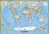
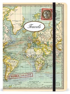
World Map 2 Travels Notebook Small

This is a unique notebook from Cavallini & Co. with a beautiful and robust cover featuring a vintage map of the world. It includes 256 lined pages, an inside back pocket and a handy elastic band to keep it tidy. This is an ideal travel companion to write notes, thoughts and plans.
RIP - This product is no longer available on our network. It was last seen on 25.09.2019

This page now acts as a permanent archive for this product. Add more information using the comments box below to ensure it can still be found by future generations.

Use our search facility to see if it is available from an alternative contributor.
  • Availability: Out Of Stock
  • Supplier: Stanfords
  • SKU: 9781574896213
Availability: In Stock
£8.99

Product Description

This is a unique notebook from Cavallini & Co. with a beautiful & robust cover featuring a vintage map of the world. It

Includes::
256 lined pages, an inside rear pocket & a handy elastic band to keep it tidy. This is an ideal travel companion to write notes, thoughts & plans.

Reviews/Comments

Add New

Intelligent Comparison

Oooops!
We couldn't find anything!
Perhaps this product's unique.... Or perhaps we are still looking for comparisons!
Click to bump this page and we'll hurry up.

Price History

Vouchers

No voucher codes found.
Do you know a voucher code for this product or supplier? Add it to Insights for others to use.

Facebook

Jargon Buster

World - A physical grouping, commonly used to describe earth and everything associated with ti
robust - An physical or metaphorical object which is well built or hard to destroy
Small - something that takes up less space than normal.
Pocket - A bag shaped insert in clothing used to carry items
Vintage - An older product that has become more quirky with time.
Ideal - Something that satisfies a perfect criteria.

Supplier Information

Stanfords
Stanfords was established in 1853 and opened their iconic Covent Garden flagship store in 1901. They have become the top retailer of maps, travel books and accessories in the UK and arguably offer the largest selection of maps and travel books worldwide. Famous names such as Captain Robert Falcon Scott, Ranulph Fiennes and Michael Palin have purchased from Stanfords. They now have a shop in Bristol and both stores together with other venues operate a calendar of events including talks, book signings and exhibitions. As a specialist map retailer, the map selection is comprehensive and includes road maps, street maps and walking maps from worldwide destinations, as well as a selection of world atlases and wall maps. Books include travel guides and travel literature. Stanfords also stock globes, from miniatures made of blue marble to magnificent floor-standing globes. The website features a selection of interesting articles on travel topics.
Page Updated: 2023-11-12 20:15:36

Community Generated Product Tags

Oh No! The productWIKI community hasn't generated any tags for this product yet!
Menu