
 United Kingdom
 France
 Germany
 Netherlands
 Sweden
 USA
USA
 Italy
Italy
 Spain
Spain
More From Contributor


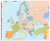
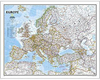
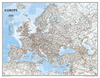

Europe Marco Polo Map
Europe at 1:2, 500, 000 on a very large, double-sided map from Marco Polo Travel Publishing, prominently highlighting interesting locations, with a 111-page index booklet attached to the map cover also showing main driving regulations in each country, etc. Cartography is from the renowned German publishers MairDumont. The map provides an overview of Europe’s road network, although for planning long-distance travel the motorway network is perhaps not sufficiently strongly differentiated from other major roads. Railway lines are included and topography is shown by relief shading with names of many physical features and regions. The map highlights numerous locations worth visiting, both towns, villages or cultural sights as well as natural places of interest such as mountains,
coastal regions and islands, etc. Latitude and longitude lines are drawn at intervals of 2°. Multilingual map legend includes English.In addition to the index, the booklet includes facts-&-figures about each country and its driving regulations, plus brief descriptions of the publishers’ choice of Europe’s 42 best sights. A fold-out flap in the cover shows for route planning an overview map of Europe, prominently highlighting main places of interest, with the grid reference system in the margins making it easier to find locations on the main map.
coastal regions and islands, etc. Latitude and longitude lines are drawn at intervals of 2°. Multilingual map legend includes English.In addition to the index, the booklet includes facts-&-figures about each country and its driving regulations, plus brief descriptions of the publishers’ choice of Europe’s 42 best sights. A fold-out flap in the cover shows for route planning an overview map of Europe, prominently highlighting main places of interest, with the grid reference system in the margins making it easier to find locations on the main map.

Product Description
Reviews/Comments
Add New
Intelligent Comparison
Archived Product

Turkey Marco Polo Map Stanfords
£6.99
Archived Product

Egypt Marco Polo Map Stanfords
£4.99
Archived Product

France Marco Polo Map Stanfords
£6.99
Archived Product
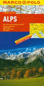
Alps Marco Polo Map Stanfords
£6.99
Archived Product

Austria Marco Polo Map Stanfords
£6.99
Archived Product

USA Marco Polo Map Stanfords
£6.99
Archived Product
Norway Marco Polo Map Stanfords
£6.99
Archived Product

Mexico Marco Polo Map Stanfords
£6.99
Vouchers
No voucher codes found.
Do you know a voucher code for this product or supplier? Add it to Insights for others to use.
Do you know a voucher code for this product or supplier? Add it to Insights for others to use.
 Denmark