
 United Kingdom
 France
 Germany
 Netherlands
 Sweden
 USA
USA
 Italy
Italy
 Spain
Spain
More From Contributor


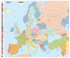


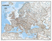
Europe NGS Classic Wall Map LARGE ENCAPSULATED
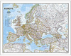
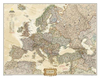
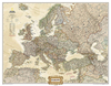
Political wall map of Europe from the National Geographic Society in their classic style with country boundaries indicated in different colours. Large size - 114 x 89cm (3ft 9” x 2ft 11” approx.) - encapsulated version.The map presents Europe in pale beige colour with relief shading to indicate mountainous regions. Additional graphics show topographic features such as main swamps or areas below the sea level. On sea the colouring indicates the continental shelf and different depths are marked. Heights are shown in feet, soundings in fathoms. Names of various mountain chains, peaks, gulfs and bays, etc, provide additional topographic information.Country borders are outlined in different colours. All place names are in their English versions. Current edition shows Kosovo as an
independent country, with a note referring to its still not fully formalized international status. Similar notes are provided for Cyprus and the Palestinian areas.The map shows the network of main road and rail connections. Also marked are selected ferry routes and North Sea oil fields. Latitude and longitude lines are drawn at 5° intervals. * This map is also available on paper without the encapsulation, and the same presentation is also published in a smaller, 77 x 60cm (30” x 24” approximately), version.*LAMINATED and ENCAPSULATED WALL MAPS:*- *laminated* wall maps have a thin layer of plastic usually applied to the printed side only. They can be written on with suitable marker pens without any damage to the map but, unless laminated on both sides, they are not damp-proof.-
*encapsulated* wall maps are sealed between two sheets of plastic. They are more rigid and heavier than laminated maps of the same size. They are damp-proof and do not crinkle in humid conditions. Encapsulation gives the map a shiny surface, similar to being displayed behind glass.- *please note:* many publishers and retailers often use these two terms interchangeably. Our map titles and descriptions follow the definitions provided above.

Product Description
Reviews/Comments
Add New
Vouchers
No voucher codes found.
Do you know a voucher code for this product or supplier? Add it to Insights for others to use.
Do you know a voucher code for this product or supplier? Add it to Insights for others to use.
 Denmark