
 United Kingdom
 France
 Germany
 Netherlands
 Sweden
 USA
USA
 Italy
Italy
 Spain
Spain
More From Contributor


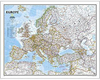
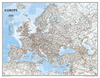

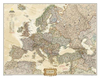

Europe Michelin Political Wall Map ENCAPSULATED
Educational and decorative, this Europe political wall map is ideal for use in both home and office. Updated annually and beautifully coloured, this map highlights flags for each European country and includes information on population, surface area and density. This map also shows main European road networks, cities and capitals.This map is in French.

Product Description
Reviews/Comments
Add New
Vouchers
No voucher codes found.
Do you know a voucher code for this product or supplier? Add it to Insights for others to use.
Do you know a voucher code for this product or supplier? Add it to Insights for others to use.
 Denmark