More From Contributor

£6.99
The Alpine areas of Europe on a large overview road map at 1:800, 000 from Marco Polo Travel Publishing with special features to aid navigation & a 64-page index booklet listing locations & geographical features, plus providing information mountain passes. Cartography is from the renowned German publishers Mair Dumont.A fold-out extension of the map cover gives at-a-glance overview of the whole area covered by the map with the adjoining regions, highlighting main places of interest & making it much easier to find various localities on the main map and/or plan a route. A set of seven peel-on/peel-off stickers, removable without damaging the map, is provided to make routes or locations more prominent when navigating. Coverage extends from the Rhône & Dijon to Vienna & Zagreb, & from Stuttgart to Tuscany & Umbria. Relief shading with spot heights & plenty of names of individual mountain chains, valleys, etc. shows the topography. Road network indicates toll barriers, motorway services, seasonal closures, roads restricted to or not recommended for caravans, steep gradients, scenic routes, etc. Towns & villages worth visiting & interesting natural features are prominently highlighted. Latitude & longitude grid is drawn at 30’ intervals. Multilingual map legend

Includes::
English. The map

Includes::
a 64-page booklet attached to its cover listing localities with postcodes, as well as geographical features such as mountains or rivers, plus places of interest. The booklet provides a comprehensive list of mountain passes indicating opening months, height & gradient, tolls & suitability for caravans. Also included is information on driving regulations in the relevant countries.


...
Archived Product
£10.99
The Arran Coastal Way is one of Scotland`s newest long-distance walks, running around the coast of the Isle of Arran for 65 miles. Arran is easily reached from Glasgow by frequent ferry from nearby Ardrossan. Famous as ` Scotland in miniature`, the island is rich in coastal scenery & wildlife, with fine castles, caves, & standing stones. This guidebook contains all you need to plan & enjoy one of Scotland`s finest circular walks such as: detailed route description; background on pre-history & history; whisky-making & wildlife on Arran; map of the entire route in 4 drop-down panels; practical information about public transport & travel; lavishly illustrated, with 75 colour photographs; &, is printed on waterproof paper. ...
Archived Product
£13.10
A large 117x 72cm wall map of the world, with the world`s time zones are shown in stripes of alternating colour. International borders are shown, & a few major cities.* Please note that although this map can be used as a wall map, it comes with a vertical fold.* ...
Archived Product
£18.00
Tuscany in the Blue Guides series focuses primarily on cultural tourism for the visitor who wishes to understand more of what they might see &, as such, the title provides thorough & objective reference information covering art, history & architecture. The guide features illustrations aimed to inform rather than just decorate, such as maps, diagrams, floor plans, architectural details & photographs. Cross referenced indexing means information is accessible & layout navigable. Selective listings of restaurants & accommodation are chosen in the belief that good, practical recommendations will contribute to the enjoyment of good art & culture. ...
Archived Product
£9.99
Map No. 74, Termeno/ Tramin
- Cavalese
- with a panorama map on the reverse, from Kompass in a series of walking maps of selected

...
Archived Product
£11.99
The Valleys of the Meuse & the Chiers in a series of cycling maps from Sportoena covering Belgium & the adjoining regions of the neighbouring countries, with local routes, long-distance cycling paths, classification according to the density of traffic, campsites & places of interest, etc. Brightly coloured base & the presentation of the road network differ greatly from what one usually sees on maps at this scale & may not appeal to all map users, but are designed to provide a clear picture not only of the recommended cycling routes but also of the alternatives along other roads. Colour coding of the routes looks at the first glance somewhat complicated but on closer inspection it does provide a very detailed classification, highlighting the recommended paths whilst at the same time indicating the density of motorized traffic on them. The maps also show routes along rivers or disused railway lines, & where cycling networks have been set up the routes with their orientation post numbers. Long-distance cycling routes are prominently marked. All other roads shown on the maps, from motorways to country lanes, are also classified according to the density of motorized traffic. The maps also show selected hiking paths & railway lines with stations. A range of symbols highlight various facilities & places of interest, including campsites & holiday villages, nature reserves, viewpoints, war cemeteries & other memorials or monuments, etc. Topography is meant to be indicated by the colouring of the base, but the gradation of the colours is too fine to provide any effective information. Wooded & heath areas are marked. Most titles are double-sided. The maps have no index or geographical coordinates. Map legend

Includes::
English.

...
Archived Product
£7.99
Twenty safe walks in the glorious Chiltern countryside. Simple routes with not too many hills, the walks are between 1 & 5 miles in length & offer plenty of variety with nature trails, woods caves & castle ruins to explore, & each walk features a halt for refereshments. ...
Archived Product
£8.25
Map No. 59, Tipperary North-Central in the Discovery series from the OSI, the Ordnance Survey of Irel&, which presents the country on detailed topographic maps at 1:50, 000, with additional overprint highlighting campsites & caravan parks, youth hostels, etc. Current 3rd edition of this map was published in October 2011. Maps in the Discovery series have contours at 10m intervals, with plenty of spot heights & additional altitude colouring. Graphics indicate different types of woodlands. An overprint highlights waymarked or unmarked walking trails as well as cycle routes. National or forest parks & nature reserves are marked & a range of symbols provide tourist information: campsites, caravan parks, youth hostels (An Óige & independent), tourist offices, parking & picnic places, & viewpoints. Golf courses indicate the number of holes. The maps also highlight antiquities & historical sites such as megalithic tombs, standing stones, battlefields, etc. Road network grades third class roads according to their widths &

Includes::
local tracks. Railways are shown with stations & the maps include other details expected of topographic mapping at this scale. Where appropriate, place names are given in both Irish & English. Each map covers an area of 40 x 30km (25 x 19 miles approximately) & has a 1km ITM (Irish Transverse Mercator) grid, plus latitude & longitude margin ticks at 1` intervals. Map legend is in Irish & English. To see the list of all the titles in this series please click on the series link.

...
Archived Product
£8.25
Map No. 74, Tipperary South in the Discovery series from the OSI, the Ordnance Survey of Irel&, which presents the country on detailed topographic maps at 1:50, 000, with additional overprint highlighting campsites & caravan parks, youth hostels, etc. Current 4th edition of this map was published in January 2013. Maps in the Discovery series have contours at 10m intervals, with plenty of spot heights & additional altitude colouring. Graphics indicate different types of woodlands. An overprint highlights waymarked or unmarked walking trails as well as cycle routes. National or forest parks & nature reserves are marked & a range of symbols provide tourist information: campsites, caravan parks, youth hostels (An Óige & independent), tourist offices, parking & picnic places, & viewpoints. Golf courses indicate the number of holes. The maps also highlight antiquities & historical sites such as megalithic tombs, standing stones, battlefields, etc. Road network grades third class roads according to their widths &

Includes::
local tracks. Railways are shown with stations & the maps include other details expected of topographic mapping at this scale. Where appropriate, place names are given in both Irish & English. Each map covers an area of 40 x 30km (25 x 19 miles approximately) & has a 1km ITM (Irish Transverse Mercator) grid, plus latitude & longitude margin ticks at 1` intervals. Map legend is in Irish & English. To see the list of all the titles in this series please click on the series link.

...
Archived Product
£9.50
The waterproof Footprint map-guide to the Cumbria Way
- the 73 mile (117km) route between Ulverstone & Carlisle. It generally follows
...
Archived Product

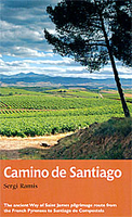
Camino De Santiago, The Way Of Saint James Pilgrimage Route Guide

The first one-volume walking guide in English to the most popular long-distance route in Europe walked by British tourists. With the advent of low-cost airlines it is as cheap for the British tourist to go to mainland Europe as to the extremities of the UK - which is why in recent years continental long-distance routes have become increasingly popular with the British walker. Most popular by far is El Camino de Santiago de Compostela, the ancient Christian pilgrimage route that has been travelled for over a thousand years to the Cathedral of Santiago de Compostela, where, legend has it, the bones of St James are buried. This guide follows the most popular route, starting at St Jean-Pied-de-Port in south-west France and heading all the way westwards across northern Spain for 800km to
finish at Cape Finisterre on the Atlantic coast.Now, extending its series of Trail Guides beyond the UK for the first time, Aurum publishes the first compact one-volume guide to the path, fully illustrated with photography, it offers comprehensive route directions, sectional route maps, gradient profiles, a history of the route and details of sights to see and separate chapter guides to the main cities along the way like Pamplona, and a list of accommodation en route.
RIP - This product is no longer available on our network. It was last seen on 25.09.2019

This page now acts as a permanent archive for this product. Add more information using the comments box below to ensure it can still be found by future generations.

Use our search facility to see if it is available from an alternative contributor.
  • Availability: Out Of Stock
  • Supplier: Stanfords
  • SKU: 9781781312230
Availability: In Stock
£14.99

Product Description

The first one-volume walking guide in English to the most popular long-distance route in Europe walked by British tourists. With the advent of low-cost airlines it is as cheap for the British tourist to go to mainland Europe as to the extremities of the UK
- which is why in recent years continental long-distance routes have become increasingly popular with the British walker. Most popular by far is El Camino de Santiago de Compostela, the ancient Christian pilgrimage route that has been travelled for over a thousand years to the Cathedral of Santiago de Compostela, where, legend has it, the bones of St James are buried. This guide follows the most popular route, starting at St Jean-Pied-de-Port in south-west France & heading all the way westwards across northern Spain for 800km to finish at Cape Finisterre on the Atlantic coast. Now, extending its series of Trail Guides beyond the UK for the first time, Aurum publishes the first compact one-volume guide to the path, fully illustrated with photography, it offers comprehensive route directions, sectional route maps, gradient profiles, a history of the route & details of sights to see & separate chapter guides to the main cities along the way like Pamplona, & a list of accommodation en route.

Reviews/Comments

Add New

Intelligent Comparison

Oooops!
We couldn't find anything!
Perhaps this product's unique.... Or perhaps we are still looking for comparisons!
Click to bump this page and we'll hurry up.

Price History

Vouchers

No voucher codes found.
Do you know a voucher code for this product or supplier? Add it to Insights for others to use.

Facebook

Jargon Buster

UK - United Kingdom - An island nation in Europe
Spain - A country within the EU.
France - A state situated in Western Europe with several overseas territories.
compact - Carefuly designed to ensure an item has a minimal physical size
History - Anything that happens in the past. An acedemic subject.
Compact - something that has a lot combined within a small space.
Accommodation - A room in which someone can live in, for example in a hotel
Popular - Something that is admired and liked by many people.

Supplier Information

Stanfords
Stanfords was established in 1853 and opened their iconic Covent Garden flagship store in 1901. They have become the top retailer of maps, travel books and accessories in the UK and arguably offer the largest selection of maps and travel books worldwide. Famous names such as Captain Robert Falcon Scott, Ranulph Fiennes and Michael Palin have purchased from Stanfords. They now have a shop in Bristol and both stores together with other venues operate a calendar of events including talks, book signings and exhibitions. As a specialist map retailer, the map selection is comprehensive and includes road maps, street maps and walking maps from worldwide destinations, as well as a selection of world atlases and wall maps. Books include travel guides and travel literature. Stanfords also stock globes, from miniatures made of blue marble to magnificent floor-standing globes. The website features a selection of interesting articles on travel topics.
Page Updated: 2023-11-12 20:15:36

Community Generated Product Tags

Oh No! The productWIKI community hasn't generated any tags for this product yet!
Menu