
 United Kingdom
 France
 Germany
 Netherlands
 Sweden
 USA
USA
 Italy
Italy
 Spain
Spain
More From Contributor


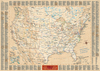
USA East Marco Polo Map
Eastern USA at 1:2, 000, 000 from Marco Polo Travel Publishing with an index which includes geographical features, 13 street plans of main cities, enlargements for two national parks, brief descriptions of 15 best sights, etc. Coverage extends to just east of the Mississippi, and north to include Toronto, Ottawa and Quebec City.Cartography is from the renowned German publisher MairDumont. Topography is presented by relief shading with plenty of names of mountain ranges, etc. Heights of peaks and passes are given in metres. The map shows the country’s network of main and secondary roads, with distances given in miles within US and in kilometres in the neighbouring parts of Canada. Scenic routes are highlighted. Main railway lines are included and the map also shows state and time
zone boundaries, national parks, Indian reservations and restricted military areas. Places of particular interest, both towns or cultural/historical sights and natural features are prominently highlighted. The map has latitude and longitude grid at intervals of 1°. Multilingual map legend includes English.Extensive index in a 32-page booklet attached to the map cover includes names of geographical features such as mountains, rivers, lakes, etc, enlargements for the Everglades and the Smoky Mountain National Parks, plus street plans of central Atlanta, Boston (downtown + Cambridge ), Chicago, Detroit, Fort Lauderdale, Miami, Miami Beach, New York City (Lower + Midtown Manhattan), Philadelphia, Savannah and Washington DC. Also provided are descriptions of 15 best sights,
lists of international and regional airports, a distance/driving times table, plus basic driving regulations.A fold-out flap in the cover shows for route planning an overview of the whole area covered by the map plus the adjacent regions, prominently highlighting main places of interest, with the grid reference system in the margins making it easier to find locations on the main map.
Product Description
Reviews/Comments
Add New
Intelligent Comparison
Archived Product
USA West Marco Polo Map Stanfords
£6.99
Archived Product

USA Marco Polo Map Stanfords
£6.99
Archived Product

Alps Marco Polo Map Stanfords
£6.99
Archived Product

Austria Marco Polo Map Stanfords
£6.99
Archived Product

Egypt Marco Polo Map Stanfords
£4.99
Archived Product

Australia Marco Polo Map Stanfords
£6.99
Archived Product

China Marco Polo Map Stanfords
£6.99
Archived Product
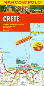
Crete Marco Polo Map Stanfords
£5.99
Vouchers
No voucher codes found.
Do you know a voucher code for this product or supplier? Add it to Insights for others to use.
Do you know a voucher code for this product or supplier? Add it to Insights for others to use.
 Denmark