
 United Kingdom
 France
 Germany
 Netherlands
 Sweden
 USA
USA
 Italy
Italy
 Spain
Spain
More From Contributor


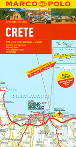
Crete Marco Polo Map
Crete at 1:150, 000 on a double-sided, indexed map from Marco Polo Travel Publishing with four street plans, plus special features to make route planning and navigating easier: a fold-out flap in the jacket shows the whole island highlighting popular locations, with the grid reference system in the margins making it easier to find various places on the main map. A set of seven peel-on/peel-off stickers, removable without damaging the map, is provided for making routes or locations more prominent when navigating.Cartography is from the renowned German publishers MairDumont. Road network shows main and secondary roads with driving distances and highlights scenic routes. Smaller country roads or tracks, presented in white on a background with relief shading, are perhaps less clear to
see than on maps with altitude colouring. In addition to the shading, topography is presented by numerous peaks and names of mountain ranges. E4 long-distance hiking route is marked, both the section across the central mountains and the variant along the south coast. Picturesque towns, places of interest and landscapes are given star rating, and other tourist information includes campsites and youth hostels, archaeological sites, churches, viewpoints, etc. All place names are given in both Greek and Latin alphabets. Latitude and longitude grid is drawn at intervals of 10`. Multilingual map legend includes English. The index is in a separate booklet attached to the map cover and also includes street plans of central Iraklion, Rethymnon, Hania, and Aghios Nikolaos, as well as a
table with distances and traveling times and main traffic and speed regulations.

Product Description
Reviews/Comments
Add New
Intelligent Comparison
Archived Product

France Marco Polo Map Stanfords
£6.99
Archived Product

Turkey Marco Polo Map Stanfords
£6.99
Archived Product

Europe Marco Polo Map Stanfords
£6.99
Archived Product

Caribbean Marco Polo Map Stanfords
£6.99
Archived Product

Egypt Marco Polo Map Stanfords
£4.99
Archived Product
USA West Marco Polo Map Stanfords
£6.99
Archived Product

USA Marco Polo Map Stanfords
£6.99
Archived Product
Netherlands Marco Polo Map Stanfords
£6.99
Vouchers
No voucher codes found.
Do you know a voucher code for this product or supplier? Add it to Insights for others to use.
Do you know a voucher code for this product or supplier? Add it to Insights for others to use.
 Denmark