
 United Kingdom
 France
 Germany
 Netherlands
 Sweden
 USA
USA
 Italy
Italy
 Spain
Spain
More From Contributor


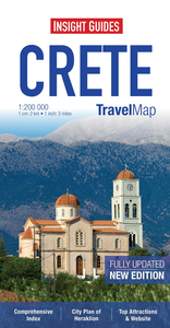
Crete Insight Travel Map
The Insight Travel Map of Crete is a large folded road map designed for tourism. Beaches, attractions and many points of interest are marked on the map, and a comprehensive index of places of interest gives website addresses for more info. The road network is clearly shown with easy to read cartography, and intermediary distances along roads are marked in kilometres. Topography is indicated with relief shading. Ferry routes are marked, and an additional inset map shows the wider ferry network around Greece & the Greek Islands, with contact numbers for operators.The map is indexed for town/place names, and for sights and points of interest. Another inset map shows a street plan of Heraklion, at 1:11, 500, with its own street index. A large part of the map is occupied by a
lower-scale (approx. 1:800, 000) regional road map of southern Greece, Crete and the Greek Islands, making this map suitable for broader trip-planning. This regional map also includes many points of interest. Most place names are shown in Greek, with transliteration in the Roman alphabet. Multilingual legend includes English.
lower-scale (approx. 1:800, 000) regional road map of southern Greece, Crete and the Greek Islands, making this map suitable for broader trip-planning. This regional map also includes many points of interest. Most place names are shown in Greek, with transliteration in the Roman alphabet. Multilingual legend includes English.

Product Description
Reviews/Comments
Add New
Vouchers
No voucher codes found.
Do you know a voucher code for this product or supplier? Add it to Insights for others to use.
Do you know a voucher code for this product or supplier? Add it to Insights for others to use.
 Denmark