More From Contributor

£12.50
Eastern Crete from Harms Verlag, with contours, altitude tints & relief shading presenting the island's mountainous terrain. Road network

Includes::
unpaved roads & shows intermediate distances on many routes. Sea ferry links & local airports are marked. An overprint shows the E4 long-distance route & several local hiking paths. Tourist information

Includes::
scenic roads, archaeological sites, campsites, youth hostels, mountain refuges, museums, bathing beaches, viewpoints, etc. Latitude & longitude lines are drawn at 10' intervals, with margin ticks at 1'. Map legend

Includes::
English. The map

Includes::
street plans of central Iraklion, Agios Nikolaos, Ierapetra & Sitia, plus a plan of the archaeological site at Knossos.


...
Archived Product
£5.99
Crete in the Essential Guides Series from the AA, exploring the best places to see & things to do in a range of popular destinations. Each illustrated, pocket-sized guide is divided into five sections
- the essence of the area, planning your trip, the best places to see, best things to do & an exploration of notable highlights, organised by area. An introductory chapter profiles each destination &

Includes::
notes on local cuisine & recommendations for short breaks. A planning section advises on pre-trip preparations & getting there & around as well as outlining useful language tips & what


...
Archived Product
£7.99
Crete in the Eyewitness Top 10 series from Dorling Kindersley is a condensed format guide book featuring dozens of illustrated, top ten lists for the traveller regardless of their disposable budget. To save you time & money a Top 10 Things to Avoid is also included. Top 10 lists are given for things to see & do across the isl&, as well as the top ten features of particular locations or events. Practicalities are not forgotten as Top 10s are also provided for topics such as planning your trip, getting around & shopping. Accommodation lists provide the ten most recommended places to stay for a range of budgets, whilst restaurant top tens feature as the guide works its way through the location in question. Simple, small street plans illustrate the location of the top ten recommends within their neighbourhoods & basic, fold out maps form the inside covers. An additional pull out feature of the guide suggests ideas on how to spend your day & a phrase section is included which will help the traveller to acclimatise. ...
Archived Product
£7.99
DK Eyewitness Top 10 Travel Guide: Crete will lead you straight to the very best on offer. Whether you're looking for the things not to miss at the Top 10 sights, or want to find the best nightspots; this guide is the perfect pocket-sized companion. Rely on dozens of Top 10 lists
- from the Top 10 museums to the Top 10 events & festivals
- there's even a list of the Top 10 things to avoid. The guide is divided by area with restaurant reviews for each, as well as recommendations for hotels, bars & places to shop. You'll find the insider knowledge every visitor needs & explore every corner effortlessly with DK Eyewitness Top 10 Travel Guide: Crete & its free pull-out map. DK Eyewitness Top 10 Travel Guide: Crete
- showing you what others only tell you.


...
Archived Product
£7.99
Crete in the Eyewitness Top 10 series from Dorling Kindersley is a condensed format guide book featuring dozens of illustrated, top ten lists for the traveller regardless of their disposable budget. To save you time & money a Top 10 Things to Avoid is also included. Top 10 lists are given for things to see & do in & around town, as well as the top ten features of particular locations or events. Practicalities are not forgotten as Top 10s are also provided for topics such as planning your trip, getting around town & shopping. Accommodation lists provide the ten most recommended places to stay for a range of budgets, whilst restaurant top tens feature as the guide works its way through the location in question. Simple, small street plans illustrate the location of the top ten recommends within their neighbourhoods & basic, fold out maps form the inside covers. An additional pull out feature of the guide suggests ideas on how to spend your day & a phrase section is included which will help the traveller to acclimatise. ...
Archived Product
£4.99
Crete on a laminated, tear-resistant Insight Flexi Map, showing the island at 1:225, 000 divided between the two sides of the map, with an index of places of interest, a street plan of central Iraklion (Heraklion), plus extensive tourist information. The map shows Crete ...
Archived Product
£5.99
Insight Flexi Map Crete: This easy to use, full-colour, water-proof map is all you need to navigate Crete. It also


...
Archived Product
£16.95
The High Mountains of Crete is Loraine Wilson’s authoritative Cicerone guide to the best walking routes in Crete’s mountainous regions. The guide covers walks in the well-known Samaria Gorge & the other dramatic gorges & numerous peaks rising to over 2100m, alongside high mountain plains, forested crags, massive cliffs & remote beaches. This new edition also

Includes::
Mount Ida in central Crete & the Lassithi mountains to the east. The guide is structured in three main parts, each encompassing specific geographical regions. Part 1 explores the White Mountains
- The Lefka Ori
- &

Includes::
the Omalos Plain, the Northern Foothills, the Askifou Plain, Anopolis, the South Coast of Sfakia & Mountain Treks. Part 2 encompasses Psilritis
- Mount Ida, including Walks & Treks from the Trailheads of the Foothills & from the Trailheads on the Nida Plain. Part 3 provides a selection of routes in the Lassithi Mountains. Each walk & trek has a Information Box with details on difficulty grading, starting & finishing points, highest points, height gain & loss, approximate distance & time allowance. A comprehensive introduction gives details on getting to Crete by plane or ferryboat, shopping & accommodation & advice on practical considerations such as equipment, weather, the best time to go & potential hazards. Detailed route descriptions are accompanied by colour sketch diagrams mapping the route as well as colour photographs illustrating some of the highlights of the region.


...
Archived Product
£4.99
This vibrant series of travel guides is aimed at travellers on a package or short-term holiday who need concise practical & accessible information. It specifically targets what people want from a few weeks holiday. Each handy guide features the best nightlife, shopping, beaches & activities & provides details for getting out & about to see local attractions. This series: contains summaries of the most popular resorts, including the best beaches, things to see & do, taking a break & after dark sections; describes the local cuisine &

Includes::
a concise phrase guide & menu decoder; gives advice on how to keep children entertained & venues that specifically cater for them; lists festivals & events throughout the year; reviews the types of sports & leisure activities on offer within the area; & features fun excursions & scenic trips locally & further afield. It contains: clear, full-colour resort maps locate restaurants, night-time venues, shopping & places of interest; & practical information for before you leave & during your stay, including visa requirements, customs, dress codes, emergencies, health & safety & currency.

...
Archived Product
£5.99
The Insight Travel Map of Crete is a large folded road map designed for tourism. Beaches, attractions & many points of interest are marked on the map, & a comprehensive index of places of interest gives website addresses for more info. The road network is clearly shown with easy to read cartography, & intermediary distances along roads are marked in kilometres. Topography is indicated with relief shading. Ferry routes are marked, & an additional inset map shows the wider ferry network around Greece & the Greek Islands, with contact numbers for operators. The map is indexed for town/place names, & for sights & points of interest. Another inset map shows a street plan of Heraklion, at 1:11, 500, with its own street index. A large part of the map is occupied by a lower-scale (approx. 1:800, 000) regional road map of southern Greece, Crete & the Greek Islands, making this map suitable for broader trip-planning. This regional map also

Includes::
many points of interest. Most place names are shown in Greek, with transliteration in the Roman alphabet. Multilingual legend

Includes::
English.


...
Archived Product

Crete F&B Top 10 Tips

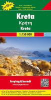
Crete in a series of Top 10 Tips maps from Freytag and Berndt covering Europe’s popular tourist destination at 1:150, 000, on a double-sided map with street plans, plans of main archaeological sites, and a booklet with brief, multilingual descriptions of the island’s 10 best locations and places of interest.Topography is shown by bold relief shading with spot heights and names of mountain ranges, peaks, etc. Road network includes a selection of small local tracks and highlights scenic routes.Picturesque towns and villages are highlighted and a range of icons mark various places of interest, including archaeological sites, churches, museums, marinas, campsites, youth hostels, golf courses, etc. The island’s 10 best sights are prominently marked and given brief
multilingual descriptions in a booklet attached to the map cover. All place names are shown in both Greek and Latin alphabets. The map has latitude and longitude lines at intervals of 10’. Map legend and the descriptions of main sights include English.Also included are street plans of central Iraklion, Rethymnon, Chania and Aghios Nikolaos, plus plans of the archaeological sites at Knossos, Festos, Aghia Triada, Zakros and Malia.
RIP - This product is no longer available on our network. It was last seen on 25.09.2019

This page now acts as a permanent archive for this product. Add more information using the comments box below to ensure it can still be found by future generations.

Use our search facility to see if it is available from an alternative contributor.
  • Availability: Out Of Stock
  • Supplier: Stanfords
  • SKU: 9783707907629
Availability: In Stock
£10.99

Product Description

Crete in a series of Top 10 Tips maps from Freytag & Berndt covering Europe’s popular tourist destination at 1:150, 000, on a double-sided map with street plans, plans of main archaeological sites, & a booklet with brief, multilingual descriptions of the island’s 10 best locations & places of interest. Topography is shown by bold relief shading with spot heights & names of mountain ranges, peaks, etc. Road network

Includes::
a selection of small local tracks & highlights scenic routes. Picturesque towns & villages are highlighted & a range of icons mark various places of interest, including archaeological sites, churches, museums, marinas, campsites, youth hostels, golf courses, etc. The island’s 10 best sights are prominently marked & given brief multilingual descriptions in a booklet attached to the map cover. All place names are shown in both Greek & Latin alphabets. The map has latitude & longitude lines at intervals of 10’. Map legend & the descriptions of main sights include English. Also included are street plans of central Iraklion, Rethymnon, Chania & Aghios Nikolaos, plus plans of the archaeological sites at Knossos, Festos, Aghia Triada, Zakros & Malia.

Reviews/Comments

Add New

Intelligent Comparison

Oooops!
We couldn't find anything!
Perhaps this product's unique.... Or perhaps we are still looking for comparisons!
Click to bump this page and we'll hurry up.

Price History

Vouchers

No voucher codes found.
Do you know a voucher code for this product or supplier? Add it to Insights for others to use.

Facebook

Jargon Buster

Network - A link and communication between things. Often computers or people.
Small - something that takes up less space than normal.
Road - a manmade lane or a path that is used to speed up travel.
Golf - A sport played on a large outside grass course, the aim to hit a small ball with a club into small holes.
Popular - Something that is admired and liked by many people.

Supplier Information

Stanfords
Stanfords was established in 1853 and opened their iconic Covent Garden flagship store in 1901. They have become the top retailer of maps, travel books and accessories in the UK and arguably offer the largest selection of maps and travel books worldwide. Famous names such as Captain Robert Falcon Scott, Ranulph Fiennes and Michael Palin have purchased from Stanfords. They now have a shop in Bristol and both stores together with other venues operate a calendar of events including talks, book signings and exhibitions. As a specialist map retailer, the map selection is comprehensive and includes road maps, street maps and walking maps from worldwide destinations, as well as a selection of world atlases and wall maps. Books include travel guides and travel literature. Stanfords also stock globes, from miniatures made of blue marble to magnificent floor-standing globes. The website features a selection of interesting articles on travel topics.
Page Updated: 2023-11-12 20:15:36

Community Generated Product Tags

Oh No! The productWIKI community hasn't generated any tags for this product yet!
Menu