
 United Kingdom
 France
 Germany
 Netherlands
 Sweden
 USA
USA
 Italy
Italy
 Spain
Spain
More From Contributor
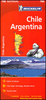

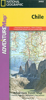
Chile Adventure Map
Chile at 1:1, 750, 000 in a series of Adventure maps from the National Geographic Society with cartography provided by Reise Know-How. The map, double-sided and printed on light waterproof and tear-resistant plastic paper, presents this unusually long country in four sections. The two central panels also provide good coverage of the Argentinian Andes, whilst the southern panel (southwards from approx. 46º) extends to all the way to the Atlantic to cover southern Patagonia.Cartographic information provided by Reise Know-How has been adjusted to follow the house style of the NGS Adventure series with greater emphasis on the country’s topography. Altitude colouring in broader bands has been replaced here by contours at 200m intervals, enhanced by relief shading with graphics for salt
flats, glaciers and names of mountain ranges, peaks, etc. Boundaries of national parks and other protected areas are very prominently highlighted.Road network distinguishes between paved and unsurfaced roads and includes selected tracks. Driving distances are shown on main and selected secondary roads and border crossings are marked. Railway lines are included, local airports are indicated and in the fjords between Puerto Montt and Puerto Natales ferry routes are marked. Internal administrative boundaries are shown with names of the provinces. Symbols highlight various places of interest and recreational areas (campsites shown on the RK-H maps are not included here). The map has a grid with latitude and longitude at intervals of 1º and an extensive index of localities with a separate
list of national parks and protected areas.Overall, the NGS map presents a more vivid picture of the country’s topography, whilst the original RK-H version provides clearer information for touring the country by road or rail.PLEASE NOTE: to ensure regular supplies and faster delivery to our customers we keep as regular stock the Reise Know-How editions whilst the NGS versions can be ordered on request.

Product Description
Reviews/Comments
Add New
Intelligent Comparison
Archived Product

China Adventure Map Stanfords
£9.99
Archived Product
Thailand Adventure Map Stanfords
£9.99
Archived Product
Belize Adventure Map Stanfords
£9.99
Archived Product
Sicily Adventure Map Stanfords
£9.99
Archived Product
Brazil Adventure Map Stanfords
£9.99
Archived Product
Peru Adventure Map Stanfords
£9.99
Archived Product
Corsica Adventure Map Stanfords
£9.99
Archived Product
China East Adventure Map Stanfords
£9.99
Vouchers
No voucher codes found.
Do you know a voucher code for this product or supplier? Add it to Insights for others to use.
Do you know a voucher code for this product or supplier? Add it to Insights for others to use.
 Denmark