
 United Kingdom
 France
 Germany
 Netherlands
 Sweden
 USA
USA
 Italy
Italy
 Spain
Spain
More From Contributor


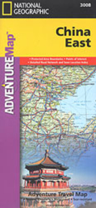
China East Adventure Map
Eastern China at 1:2, 950, 000 in a series of Adventure maps from the National Geographic Society with cartography provided by Reise Know-How. The map is double-sided and printed on light waterproof and tear-resistant synthetic paper. Place names are in the Latin alphabet, except for larger cities which are also shown is Chinese.Cartographic information provided by Reise Know-How has been adjusted to follow the house style of the NGS Adventure series with greater emphasis on the country’s topography. Altitude colouring in broader bands has been replaced here by contours at 200m intervals and relief shading.Road network is graded into five types and shows distances are on main and selected secondary routes. Railway lines are included and domestic airports are marked. Internal
administrative boundaries are shown with names of the provinces. Symbols indicate numerous places of interest, including the Great Wall and UNESCO world heritage sites, archaeological remains, etc. The map has a latitude and longitude grid at intervals of 2° and is indexed.PLEASE NOTE: to ensure faster delivery to our customers we keep this title in regular stock in the Reise Know-How version. The NGS versions can be ordered on request.
administrative boundaries are shown with names of the provinces. Symbols indicate numerous places of interest, including the Great Wall and UNESCO world heritage sites, archaeological remains, etc. The map has a latitude and longitude grid at intervals of 2° and is indexed.PLEASE NOTE: to ensure faster delivery to our customers we keep this title in regular stock in the Reise Know-How version. The NGS versions can be ordered on request.

Product Description
Reviews/Comments
Add New
Intelligent Comparison
Archived Product

China Adventure Map Stanfords
£9.99
Archived Product
Canada West Adventure Map Stanfords
£9.99
Archived Product
Australia East Adventure Map Stanfords
£9.99
Archived Product
Chile Adventure Map Stanfords
£9.99
Archived Product

Cuba Adventure Map Stanfords
£9.99
Archived Product
Corsica Adventure Map Stanfords
£9.99
Archived Product

India Northeast Adventure Map Stanfords
£9.99
Archived Product

Costa Rica Adventure Map Stanfords
£9.99
Vouchers
No voucher codes found.
Do you know a voucher code for this product or supplier? Add it to Insights for others to use.
Do you know a voucher code for this product or supplier? Add it to Insights for others to use.
 Denmark