
 United Kingdom
 France
 Germany
 Netherlands
 Sweden
 USA
USA
 Italy
Italy
 Spain
Spain
More From Contributor


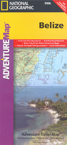
Belize Adventure Map
Belize Adventure Map at 1:400, 000 from the National Geographic Society, printed on light waterproof and tear-resistant plastic paper, with street plans of central Belize City and San Pedro, site map of Tikal, and additional tourist information.On one side is a map of Belize at 1:400, 000 designed to highlight the country’s protected areas: national parks, wildlife sanctuaries, forest, mangrove or marine reserves, etc. Coverage extends to the border areas of Guatemala including the Tikal National Park and its archaeological sites. The map has contours at 50m intervals enhanced by relief shading and colouring/graphics showing the forest cover, swamps and coral reefs in coastal waters.Numerous protected areas are highlighted, with the colouring of their boundaries indicating
their official status. Road network distinguishes between paved, gravel and dirt roads and shows border crossings and petrol stations. Local airports and ferry routes are marked. A range of symbols highlight various places of interest including Maya sites, beaches, windsurfing and snorkel ling places, diving and fishing sites, etc. The map has both UTM grid and latitude/longitude margin ticks at intervals of 15’. There is no index of localities but the map includes a list of all the protected areas from national parks to private reserves. On the reverse are street plans of central Belize City and San Pedro highlighting main sights, accommodation and other tourist facilities, plus a detailed site plan of the Maya ruins at Tikal. Also provided is advice for travellers to Belize and
descriptions of the country’s various regions illustrated with colour photos.

Product Description
Reviews/Comments
Add New
Intelligent Comparison
Archived Product
Chile Adventure Map Stanfords
£9.99
Archived Product
Mexico Adventure Map Stanfords
£9.99
Archived Product
Brazil Adventure Map Stanfords
£9.99
Archived Product
Peru Adventure Map Stanfords
£9.99
Archived Product
Ireland Adventure Map Stanfords
£9.99
Archived Product

China Adventure Map Stanfords
£9.99
Archived Product
Sicily Adventure Map Stanfords
£9.99
Archived Product

France Adventure Map Stanfords
£9.99
Vouchers
No voucher codes found.
Do you know a voucher code for this product or supplier? Add it to Insights for others to use.
Do you know a voucher code for this product or supplier? Add it to Insights for others to use.
 Denmark