More From Contributor

£10.39
Belize in the Countries, Regions & Cities series from Rough Guides; comprehensively detailed guidebooks specifically designed for independent travellers & serving a range of worldwide destinations. Widely recognised for their free editorial style, Rough Guide authors are allowed to express their personal opinions on a range of subjects. Although sometimes controversial, this editorial stance allows readers to experience more detailed & personal takes on each destination, a feature often more limited in other guidebooks. Cultural & historical nuances are explored in significant depth throughout the text & descriptions on the ambience of individual settings alongside personal recommendations, particularly in cities, are notably prevalent. Each Rough Guide in the Countries, Regions & Cities series has a similar layout. A ...
Archived Product
£9.99
Waterproof & tear-resistant, double-sided map from ITMB presenting on one side Belize at 1:300, 000 accompanied by a street plan of Belize City & on the reverse the eastern part of Guatemala at 1:470, 000 with street plans of Guatemala City & Antigua Guatemala & an enlargement showing in greater detail the environs of the capital. Coverage of Guatemala extends in the northern part of the map to Sayaxché, but in the south further west, beyond Guatemala City to Chimaltenango & Escuintla. Both countries are presented with altitude colouring to indicate their topography, plus graphics for swamps. National parks & other protected areas, including Belize’s marine parks, are prominently highlighted. Road network indicates unpaved roads &

Includes::
selected country tracks. Driving distances are shown on main routes & locations of petrol stations are marked in both countries. Railway lines are included & local airports are marked. Symbols highlight various place of interest, including both cultural & natural UNESCO World Heritage sites, beaches, diving & snorkelling sites, etc. Latitude & longitude lines are drawn at 15’ intervals in Belize & 30’ in Guatemala. Each country has a separate index. Street plans of the two capitals highlight selected accommodation, important buildings & various tourist facilities.

...
Archived Product
£11.99
Lonely Planet Belize
Spy on the rare red-footed booby before diving into the Blue Hole
Buzz across treetops on a zip-line

...
Archived Product
£13.99
Belize in the Living Abroad series from Moon, one of America’s leading travel publishers, covering a range of countries worldwide & offering practical guidance on residing away from home. Stylistically, Moon’s editorial style is strongly American in focus, often offering cultural insights & observations with an American audience in mind. However, each of the titles in the Living Abroad series has been comprehensively reviewed & researched by writers who have lived there, offering readers a knowledgeable insight into the destination. Each of the titles in the Living Abroad series is similarly arranged, allowing readers to identify the information they need easily. Individual titles serve as practical guides to the destination in addition to valuable companions while living abroad. A ‘welcome’ section profiles the country, introducing the reader to the destination, with details on social climate, history, government & economy, people & culture & planning your trip, including advice on what to bring, visas & passports, local transport & sample itineraries. The ‘ Daily Life’ section incorporates a range of practical information with useful guidance on making the move, housing considerations, language & education, health, employment, finance, communications & travel & transportation. Each chapter is presented with a series of headings & the most important things for visitors to consider. There is also a dedicated section dedicated to exploring the prime-living locations, often organised by city. An overview of the region is provided in addition to an overview map identifying the most desirable living locations; there is also further guidance on where to live, daily life & getting around. ...
Archived Product
£9.99
Belize Adventure Map at 1:400, 000 from the National Geographic Society, printed on light waterproof & tear-resistant plastic paper, with street plans of central Belize City & San Pedro, site map of Tikal, & additional tourist information. On one side is a map of Belize at 1:400, 000 designed to highlight the country’s protected areas: national parks, wildlife sanctuaries, forest, mangrove or marine reserves, etc. Coverage extends to the border areas of Guatemala including the Tikal National Park & its archaeological sites. The map has contours at 50m intervals enhanced by relief shading & colouring/graphics showing the forest cover, swamps & coral reefs in coastal waters. Numerous protected areas are highlighted, with the colouring of their boundaries indicating their official status. Road network distinguishes between paved, gravel & dirt roads & shows border crossings & petrol stations. Local airports & ferry routes are marked. A range of symbols highlight various places of interest including Maya sites, beaches, windsurfing & snorkel ling places, diving & fishing sites, etc. The map has both UTM grid & latitude/longitude margin ticks at intervals of 15’. There is no index of localities but the map

Includes::
a list of all the protected areas from national parks to private reserves. On the reverse are street plans of central Belize City & San Pedro highlighting main sights, accommodation & other tourist facilities, plus a detailed site plan of the Maya ruins at Tikal. Also provided is advice for travellers to Belize & descriptions of the country’s various regions illustrated with colour photos.

...
Archived Product
£4.99
Arenal & Costa Rica's Caribbean Coast in the Moon Spotlight guide series; covering a range of specific local cities, districts, areas & regions in North, Central & South America & targeted at those seeking to travel to a specific area within a country. Each of the guides has been extracted in full from the relevant country Moon Handbook & individual titles focus on a particular city, region or notable area of the destination. Many of the guides in the series are unique in their coverage, although are limited in putting the destination into its wider geographical context that a more comprehensive guide would provide. Stylistically, Moon ...
Archived Product
£9.99
Belize on a light, waterproof & tear-resistant map from Franco Maps designed to highlight the country’s numerous diving & snorkeling sites, with more detailed panels of main locations annotated with notes for visitors. On one side is a map of the whole country. On mainland only main roads are marked, with various places of interest & names of wildlife sanctuaries & other protected areas. Ambergris Bay & Belize’s numerous islands are annotated to show snorkeling & diving locations. On the reverse three panels provide more detailed picture of Ambergris Bay, Placencia Reefs & the atolls of Belize: Turneffe Atoll, Lighthouse Reef & Glover’s Reef. Most diving sites there are annotated with brief notes indicating their size & type, etc. Also provided is a cross-section of the Great Blue Hole Monument in the Lighthouse Reef, now a World Heritage Site. The map also

Includes::
beautiful colour drawings of various types of fish & corals found in this part of the Caribbean.

...
Archived Product
£11.99
Belize in the Diving & Snorkeling series from Lonely Planet; exploring the diving opportunities in a range of popular international diving sites. Frank & informal in style, the guides offer practical advice to travelers on specific diving holidays or those wanting to dive or snorkel while away. The guides offer practical advice on a large number of diving sites in the region & are suitable for advanced divers & novices alike. Widely recognized for their reliability, each Lonely Planet Diving & Snorkeling guide has the same layout. Extensive introductory chapters cover facts about the region, including history, geography & language, practical guidance on what to bring, the rating system for dives & divers, ...
Archived Product
£25.00
We are able to source a wide range of courtesy flags. Flags are available in many sizes & can be sewn or printed on 100% Ministry Of Defence Standard Woven & Knitted Polyester. Flags are supplied with rope & toggle. If you would like more information, have a custom size request or cannot find a desired product, please email us at maritime@stanfords.co.uk. We will be glad to help! ...
Archived Product
£12.99
Central America Handbook in the Handbooks series from Footprint; comprehensive & leading guides designed & written for independent travellers who enjoy exploring off the beaten track. Footprint guides have an established reputation, built up since 1921, for catering for more adventurous & individual travellers. An unrestrictive editorial style also gives authors the freedom to capture & explore local cultures, sights & areas that are often not covered in other guides. Widely recognised for their reliability & independent writing style, Footprint guides all have the same layout. Introductory sections introduce the reader to the destination, with chapters on planning on your trip & essentials, including practical information & guidance on subjects such as when & where to go, itineraries, sport & activities, arts, getting there & around, eating & drinks, sleeping & a dedicated section on the anticipated carbon footprint involved in travelling to the destination. Each guide is organised geographically by region or country, with individual sections having a particular focus on an extensive range of sights & places of interest. Further, there are also details of accommodation, nightlife, restaurants & any notable local activities. Information boxes throughout the text give readers an insight into local customs, stories & sights of particular interest.A ‘ Background’ section explores the history, economy, government, education, culture, people, land & environment of the destination in significant depth. There is also a ‘ Footnotes’ chapter with a basic language guide for travellers & information about the author. A useful distance chart tailored to the destination is also included in the inside back cover. * Please note:* the series is gradually being revised, reverting to its previous style of ” Handbooks”, published in a hardback format. ...
Archived Product

Belize Borch

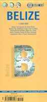
Laminated, waterproof and tear-resistant tourist map of Belize, with a street plan of central Belize City, enlargement of the Ambergris Caye and Caye Caulker area, plans of eight main archaeological sites and an overview map of the whole of Yucatan Peninsula.The main map covers the country at 1:500, 000, extending west into Guatemala to Lake Petén Itzá and the towns of Flores and Santo Benito. Topography is shown by relief shading with spot heights and markings for swamps and mangroves. Road network shows locations of petrol stations. National parks and other protected areas are prominently highlighted and the map indicates numerous places of interest including archaeological sites and Maya temples, caves, beaches, scuba diving and snorkeling sites, etc. Also shown are the
countries internal administrative boundaries with names of the provinces.On the reverse is a street plan of central Belize City, an enlargement at 1:250, 000 of the Ambergris Caye and Caye Caulker area, and the map of the whole of Maya region, from Tuxtla Gutierrez in Mexico to Tegucigalpa in Honduras, all annotated with symbols highlighting places of interest. All three maps and the street plan are indexed, with separate lists of sights, etc. Map legend includes English.Plans at scales from 1:9, 000 to 1:3, 000 show the archaeological sites at Altun Ha, Cahal Pech, Caracol, El Pilar, Lamanai, Lubaantun, Nim Li Punit and Xunantunich. Also provided is information on the country’s climate and a small administrative map of Belize.
RIP - This product is no longer available on our network. It was last seen on 25.09.2019

This page now acts as a permanent archive for this product. Add more information using the comments box below to ensure it can still be found by future generations.

Use our search facility to see if it is available from an alternative contributor.
  • External links may include paid for promotion
  • Availability: Out Of Stock
  • Supplier: Stanfords
  • SKU: 9783866093997
Availability: In Stock
£9.99

Product Description

Laminated, waterproof & tear-resistant tourist map of Belize, with a street plan of central Belize City, enlargement of the Ambergris Caye & Caye Caulker area, plans of eight main archaeological sites & an overview map of the whole of Yucatan Peninsula. The main map covers the country at 1:500, 000, extending west into Guatemala to Lake Petén Itzá & the towns of Flores & Santo Benito. Topography is shown by relief shading with spot heights & markings for swamps & mangroves. Road network shows locations of petrol stations. National parks & other protected areas are prominently highlighted & the map indicates numerous places of interest including archaeological sites & Maya temples, caves, beaches, scuba diving & snorkeling sites, etc. Also shown are the countries internal administrative boundaries with names of the provinces. On the reverse is a street plan of central Belize City, an enlargement at 1:250, 000 of the Ambergris Caye & Caye Caulker area, & the map of the whole of Maya region, from Tuxtla Gutierrez in Mexico to Tegucigalpa in Honduras, all annotated with symbols highlighting places of interest. All three maps & the street plan are indexed, with separate lists of sights, etc. Map legend

Includes::
English. Plans at scales from 1:9, 000 to 1:3, 000 show the archaeological sites at Altun Ha, Cahal Pech, Caracol, El Pilar, Lamanai, Lubaantun, Nim Li Punit & Xunantunich. Also provided is information on the country’s climate & a small administrative map of Belize.

Reviews/Comments

Add New

Intelligent Comparison

Oooops!
We couldn't find anything!
Perhaps this product's unique.... Or perhaps we are still looking for comparisons!
Click to bump this page and we'll hurry up.

Price History

Vouchers

No voucher codes found.
Do you know a voucher code for this product or supplier? Add it to Insights for others to use.

Facebook

Jargon Buster

Waterproof - Resistant to water, usualy specified by depth in metres
Network - A link and communication between things. Often computers or people.
Small - something that takes up less space than normal.
Road - a manmade lane or a path that is used to speed up travel.
Resistant - Something that can repel against something.
Laminated - A thin layer of plastic that gives a coating and shine to a material.

Supplier Information

Stanfords
Stanfords was established in 1853 and opened their iconic Covent Garden flagship store in 1901. They have become the top retailer of maps, travel books and accessories in the UK and arguably offer the largest selection of maps and travel books worldwide. Famous names such as Captain Robert Falcon Scott, Ranulph Fiennes and Michael Palin have purchased from Stanfords. They now have a shop in Bristol and both stores together with other venues operate a calendar of events including talks, book signings and exhibitions. As a specialist map retailer, the map selection is comprehensive and includes road maps, street maps and walking maps from worldwide destinations, as well as a selection of world atlases and wall maps. Books include travel guides and travel literature. Stanfords also stock globes, from miniatures made of blue marble to magnificent floor-standing globes. The website features a selection of interesting articles on travel topics.
Page Updated: 2023-11-12 20:15:36

Community Generated Product Tags

Oh No! The productWIKI community hasn't generated any tags for this product yet!
Menu