
 United Kingdom
 France
 Germany
 Netherlands
 Sweden
 USA
USA
 Italy
Italy
 Spain
Spain
More From Contributor


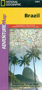
Brazil Adventure Map
Brazil at 1:4, 200, 000 in a series of Adventure maps from the National Geographic Society with cartography provided by Reise Know-How. The map is double-sided and printed on light waterproof and tear-resistant plastic paper.The map divides the country west/east, with the whole of the Brazilian Amazon Basin on one side and on the reverse the country south of the mouth of the Amazon and eastwards from Mato Grosso, with a generous overlap between the two sides. Coverage includes the whole of Paraguay, most of Bolivia with La Paz, Cochabamba and Oruro, north-eastern Peru with Iquitos and south-eastern with Cusco and Arequipa.Cartographic information provided by Reise Know-How has been adjusted to follow the house style of the NGS Adventure series with greater emphasis on the country’s
topography. Altitude colouring in broader bands has been replaced here by contours at 200m intervals. Boundaries of national parks and other protected areas are very prominently highlighted.Road network indicates unsurfaced sections, includes local tracks, and gives driving distances on main and secondary roads. Railway lines are included and local airports are marked. Internal administrative boundaries are shown with names of the states. Symbols highlight various places of interest, including archaeological remains, viewpoints, thermal spas, etc. The map has a grid with latitude and longitude at intervals of 2º and an index of localities. Overall, the smaller scale of the NGS map and particularly the less varied presentation and colouring of the road network make the original
Reise Know-How edition far clearer than the NGS map.PLEASE NOTE: to ensure regular supplies and faster delivery to our customers we keep as regular stock the Reise Know-How edition whilst the NGS version can be ordered on request.

Product Description
Reviews/Comments
Add New
Intelligent Comparison
Archived Product
Chile Adventure Map Stanfords
£9.99
Archived Product
Thailand Adventure Map Stanfords
£9.99
Archived Product
Belize Adventure Map Stanfords
£9.99
Archived Product
Sicily Adventure Map Stanfords
£9.99
Archived Product

Australia Adventure Map Stanfords
£9.99
Archived Product
Peru Adventure Map Stanfords
£9.99
Archived Product

Mayan Adventure Map Stanfords
£9.95
Archived Product

China Adventure Map Stanfords
£9.99
Vouchers
No voucher codes found.
Do you know a voucher code for this product or supplier? Add it to Insights for others to use.
Do you know a voucher code for this product or supplier? Add it to Insights for others to use.
 Denmark