
 United Kingdom
 France
 Germany
 Netherlands
 Sweden
 USA
USA
 Italy
Italy
 Spain
Spain
More From Contributor


Caucasus F&B
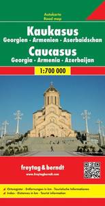
The Caucasus countries, Georgia, Armenia and Azerbaijan, on an indexed road map from Freytag and Berndt, with coverage of the adjoining Russian republics of Chechnya, Northern Ossetia, Kabardino-Balkaria and Karachaevo-circassia. International borders and internal administrative boundaries are clearly shown, indicating Southern Ossetia and Abkhazia in Georgia, as well Nagorno-Karabakh and the Azerbaijani enclave within Armenia. Names of larger towns in Georgia, Armenia and Russia are also given in each country’s alphabet.Topography is shown by relief shading and numerous spot heights, plus names of many chains within the Caucasus Mountains. Road network shows border crossings and driving distances on primary routes, and includes many secondary local roads and tracks. Railway
lines and local airports are also shown.Symbols mark main places of interest including World Heritage sites, and national parks or nature reserves are highlighted. The map has latitude and longitude lines at intervals of 1º. The index is in a separate booklet attached to the map cover.Map legend includes English.
lines and local airports are also shown.Symbols mark main places of interest including World Heritage sites, and national parks or nature reserves are highlighted. The map has latitude and longitude lines at intervals of 1º. The index is in a separate booklet attached to the map cover.Map legend includes English.

Product Description
Reviews/Comments
Add New
Intelligent Comparison
Archived Product

Caucasus ITMB Stanfords
£9.99
Archived Product
Caucasus Stanfords
£9.50
Archived Product
Caracas F&B Stanfords
£9.99
Archived Product
Caucasus Bezingi Stanfords
£8.95
Vouchers
No voucher codes found.
Do you know a voucher code for this product or supplier? Add it to Insights for others to use.
Do you know a voucher code for this product or supplier? Add it to Insights for others to use.
 Denmark