
 United Kingdom
 France
 Germany
 Netherlands
 Sweden
 USA
USA
 Italy
Italy
 Spain
Spain
More From Contributor


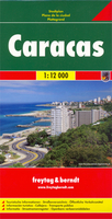
Caracas F&B
Caracas on a large indexed street plan at 1:12, 000 from Freytag & Berndt covering the city with its outer districts and showing metro stations, various places of interest and facilities, etc. Coverage extends north to El Avila National Park and south to the La Rinconada race track, Baruta, Canta Rana and Alto Hatillo. West/east the plan extends from Perez Bonalde, Vista Alegre and La Vega districts to beyond the city’s Gen. Francisco de Miranda Airport to Le Marques California Norte, California Sur and Vista Linda districts.Principal traffic arteries are highlighted and exits onto the motorway are clearly drawn. The plan shows metro lines with stations and highlights various public buildings and facilities, including locations of several hotels. Street index is on the reverse.
Multilingual map legend includes English.
Multilingual map legend includes English.

Product Description
Reviews/Comments
Add New
Intelligent Comparison
Archived Product

Caucasus F&B Stanfords
£10.99
Archived Product

Canada F&B Stanfords
£10.99
Vouchers
No voucher codes found.
Do you know a voucher code for this product or supplier? Add it to Insights for others to use.
Do you know a voucher code for this product or supplier? Add it to Insights for others to use.
 Denmark