
 United Kingdom
 France
 Germany
 Netherlands
 Sweden
 USA
USA
 Italy
Italy
 Spain
Spain
More From Contributor


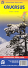

Caucasus Central
Clear topographic mapping of the central Caucasus with roads, tracks, paths and bus routes marked. Spot heights and contours at 100m intervals show the relief. Glaciers, rivers, cliffs marshes and forest areas are also marked. Latitude and Longitude grid at 30' intervals. On the reverse there is additional information for trekkers, including information about the towns in the area and a list of first ascents of the principal peaks
Product Description
Reviews/Comments
Add New
Intelligent Comparison
Archived Product

Massif Central Stanfords
£7.99
Archived Product
Haut Atlas Central Stanfords
£8.95
Vouchers
No voucher codes found.
Do you know a voucher code for this product or supplier? Add it to Insights for others to use.
Do you know a voucher code for this product or supplier? Add it to Insights for others to use.
 Denmark