
 United Kingdom
 France
 Germany
 Netherlands
 Sweden
 USA
USA
 Italy
Italy
 Spain
Spain
More From Contributor

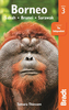

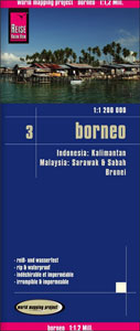
Borneo Reise Know-How
Borneo at 1:1, 200, 000 on light, waterproof and tear-resistant plastic paper, with both topographic and tourist information. The map, part of Reise Know-How`s highly acclaimed ”World Mapping Project”, is double-sided to provide the best balance between a good scale and a convenient size sheet. On one side are the Malaysian provinces of Sarawak and Sabah, Brunei, plus the northern part of Indonesian Kalimantan, with the rest of Kalimantan on the reverse.Topography is shown by altitude colouring with spot heights and graphics indicating swamps, mangroves and coral reefs in the coastal waters. Detailed presentation of the road network includes dirt roads and local tracks; railways, local airports and ferry connections. Local administrative units are shown with their boundaries
and names. National parks and other protected areas are highlighted. Symbols shows various places of interest including mosques, museums and longhouses as well as caves, coral, etc. Latitude and longitude lines are drawn at 1º intervals. The map has an extensive index of localities and the map legend includes English.To see other Reise Know-How maps covering the islands of Indonesia please click on the series link.
and names. National parks and other protected areas are highlighted. Symbols shows various places of interest including mosques, museums and longhouses as well as caves, coral, etc. Latitude and longitude lines are drawn at 1º intervals. The map has an extensive index of localities and the map legend includes English.To see other Reise Know-How maps covering the islands of Indonesia please click on the series link.

Product Description
Reviews/Comments
Add New
Intelligent Comparison
Archived Product
Ukraine Reise Know-How Stanfords
£10.50
Archived Product
Corfu Reise Know-How Stanfords
£10.50
Archived Product
Brazil Reise Know-How Stanfords
£10.50
Archived Product
Crimea Reise Know-How Stanfords
£10.50
Archived Product
Poland Reise Know-How Stanfords
£10.50
Archived Product

Yemen Reise Know-How Stanfords
£10.50
Archived Product
Istria Reise Know-How Stanfords
£10.50
Archived Product
Taiwan Reise Know-How Stanfords
£10.50
Vouchers
No voucher codes found.
Do you know a voucher code for this product or supplier? Add it to Insights for others to use.
Do you know a voucher code for this product or supplier? Add it to Insights for others to use.
 Denmark