
 United Kingdom
 France
 Germany
 Netherlands
 Sweden
 USA
USA
 Italy
Italy
 Spain
Spain
More From Contributor


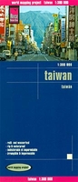
Taiwan Reise Know-How
Taiwan at 1:300, 000 on an indexed, waterproof and tear-resistant road map with topographic and tourist information, published by Reise Know-How as part of their highly acclaimed World Mapping Project. The map is double-sided to provide the best balance between a good scale and a convenient size sheet.The map divides Taiwan north/south with a generous overlap between the sides. Light altitude colouring with contours at 500m intervals and peak heights presents the country’s topography. National parks and other protected areas are marked. Names of towns and villages are in both Latin and Chinese alphabets; names of administrative provinces, geographical features and places of interest are shown only in the Latin alphabet.Road network indicates toll motorways and includes small local
roads and seasonal tracks. Driving distances are marked on main routes. Railway lines indicate high speed routes; local airports and ferry connections to the offshore islands are marked. The map also shows internal administrative divisions with names of the provinces. The map highlights various places of interest including beaches and diving or surfing sites. Latitude and longitude lines are drawn at intervals of 20’. The index of localities lists names in both scripts. Map legend includes English.*”World Mapping Project”* is an extensive series of maps at varying scales, aiming to provide coverage of countries and regions worldwide using clear, well presented cartography with both topographic and tourist information.
roads and seasonal tracks. Driving distances are marked on main routes. Railway lines indicate high speed routes; local airports and ferry connections to the offshore islands are marked. The map also shows internal administrative divisions with names of the provinces. The map highlights various places of interest including beaches and diving or surfing sites. Latitude and longitude lines are drawn at intervals of 20’. The index of localities lists names in both scripts. Map legend includes English.*”World Mapping Project”* is an extensive series of maps at varying scales, aiming to provide coverage of countries and regions worldwide using clear, well presented cartography with both topographic and tourist information.

Product Description
Reviews/Comments
Add New
Vouchers
No voucher codes found.
Do you know a voucher code for this product or supplier? Add it to Insights for others to use.
Do you know a voucher code for this product or supplier? Add it to Insights for others to use.
 Denmark