More From Contributor

£21.95
Brazil at 1:5, 000, 000 on a large wall map, encapsulated version, from the National Geographic Society showing the division of the country into administrative states, together with the rail & road networks & basic topographic information. The predominantly white base map has subtle relief shading, with names of mountain ranges & spot heights. Graphics show main swamp regions & colouring highlights national parks & other protected areas. Numerous rivers are named, particularly within the Amazon Basin. The map shows the country ...
Archived Product
£15.95
Brazil at 1:5, 000, 000 on a large wall map, paper version, from the National Geographic Society showing the division of the country into administrative states, together with the rail & road networks & basic topographic information. The predominantly white base map has subtle relief shading, with names of mountain ranges & spot heights. Graphics show main swamp regions & colouring highlights national parks & other protected areas. Numerous rivers are named, particularly within the Amazon Basin. The map shows the country ...
Archived Product
£33.99
Brazil at 1:5, 000, 000 on a large wall map, encapsulated version, in the National Geographic Society’s Executive style which offers current information presented in elegant antique style of muted shades of beige, with internal state boundaries outlined in green. The base map has subtle relief shading, with names of mountain ranges & spot heights in metres. Graphics show main swamp regions & colouring highlights national parks & other protected areas. Numerous rivers are named, particularly within the Amazon Basin. The map shows the country’s road network, including the Trans-Amazon Highway; main railway lines & local airports are also included. Internal administrative boundaries & names of the states are clearly marked. The map has latitude & longitude lines at intervals of 6°.* This wall map is also available on paper without the encapsulation.LAMINATED & ENCAPSULATED WALL MAPS:- LAMINATED wall maps have a thin layer of plastic usually applied to the printed side only. They can be written on with suitable marker pens without any damage to the map but, unless laminated on both sides, they are not damp-proof.- ENCAPSULATED wall maps are sealed between two sheets of plastic. They are more rigid & heavier than laminated maps of the same size. They are damp-proof & do not crinkle in humid conditions. Encapsulation gives the map a shiny surface, similar to being displayed behind glass.- PLEASE NOTE: many publishers & retailers often use these two terms interchangeably. Our map titles & descriptions follow the definitions provided ...
Archived Product
£19.99
Brazil at 1:5, 000, 000 on a large wall map, paper version, in the National Geographic Society’s Executive style which offers current information presented in elegant antique style of muted shades of beige, with internal state boundaries outlined in green. The base map has subtle relief shading, with names of mountain ranges & spot heights in metres. Graphics show main swamp regions & colouring highlights national parks & other protected areas. Numerous rivers are named, particularly within the Amazon Basin. The map shows the country’s road network, including the Trans-Amazon Highway; main railway lines & local airports are also included. Internal administrative boundaries & names of the states are clearly marked. The map has latitude & longitude lines at intervals of 6°.* This wall map is also available encapsulated. ...
Archived Product
£6.99
A detailed physical map with hillshading & layer colouring which shows the main transportation links & tourist features of Brazil. All of the country is covered, extending from the Atlantic coast to its borders with the Guayanas, Colombia, Peru, Bolivia, Paraguay, Argentina & Uruguay. A transport links map & distance chart are included as is a comprehensive place name index on reverse of the sheet. There is a city map of Rio de Janeiro included. ...
Archived Product
£9.50
Southern Brazil at 1:1, 200, 0000 on an indexed, waterproof & tear-resistant road map with topographic & tourist information, published by Reise Know-How as part of their highly acclaimed World Mapping Project, The map is double-sided to provide the best balance between a good scale & a convenient size sheet. The map divides the area north/south, presenting on one side the region with Rio de Janeiro, S ...
Archived Product
£5.95
Southern Brazil at 1:2, 500, 000 from Nelles Verlag, with a smaller size sheet offering a convenient format for use when travelling. The map

Includes::
several insets with street plans or enlargements of environs of main cities. The map divides the whole region north/south, with Rio de Janeiro & S

...
Archived Product
£9.99
Brazil in the AA Spiral Guides series; comprising a selection of titles exploring a wide range of cities, regions & countries in a handy, spiral loose-leaf format. Fold-out flaps at the front & back of each title give an overview of the main regions covered, with page numbers so visitors can locate their destination easily. Each guide explores the destination geographically by region or area & provides the essential information for the main sites & attractions in addition to a recommended tour of each area by car. An introductory section - ...
Archived Product
£22.50
The world is open for travel & people are looking for new ways to experience a destination. The acclaimed National Geographic Traveler series offers just that. Each guide presents the place in full, beginning with an overview to help develop a game plan. Popular features include insider tips from National Geographic experts; not-to-be-missed lists; experiential sidebars; sections on contemporary life, history, & culture; special excursions; handy maps; & a hefty Travelwise selection with handpicked hotels & restaurants. This beautiful guide makes Brazil accessible to every traveller. Rising star in tourism world: With the 2014 World Cup & 2016 Olympic Games coming, Brazil is preparing for an onslaught of visitors who will be a ready audience for this guide. Exciting features & suggestions: This guide provides a game plan for visitors interested in taking in the best sites around the country, with a focus on active experiences that give travellers behind-the-scenes possibilities; insider tips from National Geographic photographers, writers, & experts; not-to-be-missed lists; & a practical introduction. Content

Includes::
popular walking & driving tours; features on contemporary life, history, & culture; & excursions off the beaten path offering the most authentic & meaningful experience.

...
Archived Product
£12.99
This exciting guide aims to inspire & help travellers to plan & enjoy tours in Brazil's finest wildlife reserves. In addition to offering advice on planning your trip & discussing available options as well as park etiquette, the guide offers an overview of Brazil's natural environment & wildlife, including an informative gallery of species. Brazil's 10 best parks or groupings of parks are profiled, which

Includes::
an overview of the featured park, a brief history, a description by area of the park, & special features to look out for. The parks all offer breath-taking scenic beauty, game viewing, a range of accommodation & facilities as well as tours & walks or hikes. Each park profile also
Includes:: panels on matters of special interest; scenic & wildlife photographs; detailed maps showing biomes, routes, camps, picnic spots, scenic spots, places to see, etc; tables showing the range of accommodation, activities & facilities available; what to look out for at which time of year; game-viewing checklist; gate opening- & closing- times; & contact details of featured park, for bookings.


...
Archived Product

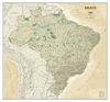
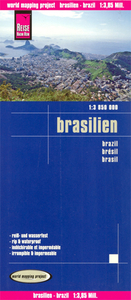
Brazil Reise Know-How

Brazil at 1:3, 850, 000 on an indexed, waterproof and tear-resistant road map with topographic and tourist information, published by Reise Know-How as part of their highly acclaimed World Mapping Project, The map is double-sided to provide the best balance between a good scale and a convenient size sheet.The map divides the country west/east, with the whole of the Brazilian Amazon Basin on one side and on the reverse the country south of the mouth of the Amazon and eastwards from Mato Grosso, with a generous overlap between the two sides. Coverage includes the whole of Paraguay, most of Bolivia with La Paz, Cochabamba and Oruro, and Peru north-eastern with Iquitos and south-eastern with Cusco and Arequipa.Topography is shown by altitude colouring with contours and spot heights,
graphics for swamps and salt pans, plus names of hill and mountain ranges, etc. Numerous tributaries of the Amazon, including many smaller rivers not directly flowing into it, are named. The map also shows boundaries of national parks and other protected area, plus numerous Indian reservations.Road network indicates unsurfaced sections, includes local tracks, and gives driving distances on main and secondary roads. Railway lines are included and local airports are marked. Internal administrative boundaries are shown with names of the states. Symbols highlight various places of interest, including archaeological remains, viewpoints, thermal spas, etc. The map has a grid with latitude and longitude at intervals of 2º and an index of localities. Map legend includes English.
*”World Mapping Project”* is an extensive series of maps at varying scales, aiming to provide coverage of countries and regions worldwide using clear, well presented cartography with both topographic and tourist information.
RIP - This product is no longer available on our network. It was last seen on 25.09.2019

This page now acts as a permanent archive for this product. Add more information using the comments box below to ensure it can still be found by future generations.

Use our search facility to see if it is available from an alternative contributor.
  • External links may include paid for promotion
  • Availability: Out Of Stock
  • Supplier: Stanfords
  • SKU: 9783831771493
Availability: In Stock
£10.50

Product Description

Brazil at 1:3, 850, 000 on an indexed, waterproof & tear-resistant road map with topographic & tourist information, published by Reise Know-How as part of their highly acclaimed World Mapping Project, The map is double-sided to provide the best balance between a good scale & a convenient size sheet. The map divides the country west/east, with the whole of the Brazilian Amazon Basin on one side & on the reverse the country south of the mouth of the Amazon & eastwards from Mato Grosso, with a generous overlap between the two sides. Coverage

Includes::
the whole of Paraguay, most of Bolivia with La Paz, Cochabamba & Oruro, & Peru north-eastern with Iquitos & south-eastern with Cusco & Arequipa. Topography is shown by altitude colouring with contours & spot heights, graphics for swamps & salt pans, plus names of hill & mountain ranges, etc. Numerous tributaries of the Amazon, including many smaller rivers not directly flowing into it, are named. The map also shows boundaries of national parks & other protected area, plus numerous Indian reservations. Road network indicates unsurfaced sections,

Includes::
local tracks, & gives driving distances on main & secondary roads. Railway lines are included & local airports are marked. Internal administrative boundaries are shown with names of the states. Symbols highlight various places of interest, including archaeological remains, viewpoints, thermal spas, etc. The map has a grid with latitude & longitude at intervals of 2º & an index of localities. Map legend

Includes::
English. *” World Mapping Project”* is an extensive series of maps at varying scales, aiming to provide coverage of countries & regions worldwide using clear, well presented cartography with both topographic & tourist information.

Reviews/Comments

Add New

Price History

Vouchers

No voucher codes found.
Do you know a voucher code for this product or supplier? Add it to Insights for others to use.

Facebook

Jargon Buster

Brazil - A country in South America
Graphics - A general term for visual aspects of an item/display
Waterproof - Resistant to water, usualy specified by depth in metres
World - A physical grouping, commonly used to describe earth and everything associated with ti
Size - is the measurement of how big an object is in space.
Network - A link and communication between things. Often computers or people.
Road - a manmade lane or a path that is used to speed up travel.
Resistant - Something that can repel against something.
Altitude - Something that can be quite high in relation to sea or ground level.
Balance - Something that is evenly weighted to keep something upright.
Convenient - Something that suits and fits well to other activities.

Supplier Information

Stanfords
Stanfords was established in 1853 and opened their iconic Covent Garden flagship store in 1901. They have become the top retailer of maps, travel books and accessories in the UK and arguably offer the largest selection of maps and travel books worldwide. Famous names such as Captain Robert Falcon Scott, Ranulph Fiennes and Michael Palin have purchased from Stanfords. They now have a shop in Bristol and both stores together with other venues operate a calendar of events including talks, book signings and exhibitions. As a specialist map retailer, the map selection is comprehensive and includes road maps, street maps and walking maps from worldwide destinations, as well as a selection of world atlases and wall maps. Books include travel guides and travel literature. Stanfords also stock globes, from miniatures made of blue marble to magnificent floor-standing globes. The website features a selection of interesting articles on travel topics.
Page Updated: 2023-11-12 20:15:36

Community Generated Product Tags

Oh No! The productWIKI community hasn't generated any tags for this product yet!
Menu