
 United Kingdom
 France
 Germany
 Netherlands
 Sweden
 USA
USA
 Italy
Italy
 Spain
Spain
More From Contributor


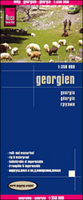
Georgia Reise Know-How
Georgia at 1:350, 000 on an indexed, waterproof and tear-resistant road map with topographic and tourist information, published by Reise Know-How as part of their highly acclaimed World Mapping Project. All place names are in the Latin alphabet, with larger towns also in the Georgian script, plus in Abkhazia in Cyrillic.The map is double-sided, dividing the country east/west with a good overlap between the sides, and shows Abkhazia and South Ossetia as administrative provinces of Georgia, although their currently different status is indicated by inclusion of signs for “closed frontier crossings”.Topography is indicated by light, unobtrusive altitude colouring, plus plenty of names of mountain ranges, peaks and passes with heights, glaciers, etc. National parks and other
protected areas are highlighted. Road network includes selected unpaved seasonal tracks and gives driving distances on main routes. Railway lines are shown and local airports are marked. Symbols highlight various places of interest including UNESCO World Heritage sites, archaeological remains, religious buildings, beaches, winter sports area, etc. The map has latitude and longitude lines at 20’ intervals and is indexed. Map legend includes English.”World Mapping Project” is an extensive series of maps at varying scales, aiming to provide coverage of countries and regions worldwide using clear, well presented cartography with both topographic and tourist information.
protected areas are highlighted. Road network includes selected unpaved seasonal tracks and gives driving distances on main routes. Railway lines are shown and local airports are marked. Symbols highlight various places of interest including UNESCO World Heritage sites, archaeological remains, religious buildings, beaches, winter sports area, etc. The map has latitude and longitude lines at 20’ intervals and is indexed. Map legend includes English.”World Mapping Project” is an extensive series of maps at varying scales, aiming to provide coverage of countries and regions worldwide using clear, well presented cartography with both topographic and tourist information.

Product Description
Reviews/Comments
Add New
Vouchers
No voucher codes found.
Do you know a voucher code for this product or supplier? Add it to Insights for others to use.
Do you know a voucher code for this product or supplier? Add it to Insights for others to use.
 Denmark