
 United Kingdom
 France
 Germany
 Netherlands
 Sweden
 USA
USA
 Italy
Italy
 Spain
Spain
More From Contributor


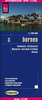
Borneo / Kalimantan ITMB
Indexed, double-sided map of the whole of Borneo at 1:1, 130, 000, showing Indonesian Kalimantan, Brunei and the Malaysian states of Sarawak and Sabah, with street plans of Kuching, Kota Kinabalu and Bandar Seri Bengawan.The island’s topography is shown by altitude colouring, with numerous spot heights (in feet), names of main peaks and swamp areas. Road network includes minor roads and locations of local airfields are indicated. Symbols highlight places of interest, selected tourist accommodation, beaches, etc. Internal boundaries and names of administrative units are shown in all three countries. The map has latitude and longitude grid at intervals of 1º and an index of localities, repeated on both sides of the map.Insets show central parts of Kuching, Kota Kinabalu and
Bandar Seri Bengawan, with tourist accommodation, places of interest and various facilities.
Bandar Seri Bengawan, with tourist accommodation, places of interest and various facilities.
Product Description
Reviews/Comments
Add New
Vouchers
No voucher codes found.
Do you know a voucher code for this product or supplier? Add it to Insights for others to use.
Do you know a voucher code for this product or supplier? Add it to Insights for others to use.
 Denmark