
 United Kingdom
 France
 Germany
 Netherlands
 Sweden
 USA
USA
 Italy
Italy
 Spain
Spain
More From Contributor


Belarus
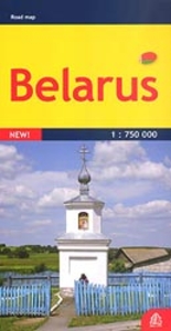
Belarus at 1:750, 000 on an indexed detailed road map from the Riga-based Jana Seta publishers showing a large number of small villages and highlighting various locations of interest. All place names are shown transliterated. The map shows the country’s road network, including selected local dirt tracks, indicating driving distance on main routes and border crossings with full or limited access. Railway lines are also included and local airports are marked. The map also shows internal administrative boundaries with names of the provinces. Towns or villages and other places of interest are highlighted. The terrain is shown by colouring for woodlands and graphics for marshlands. National parks are highlighted. Also marked is the extent of the zone affected by the Chernobyl explosion. The
map has latitude and longitude lines at intervals of 30’. The index is on the reverse. Map legend includes English.
map has latitude and longitude lines at intervals of 30’. The index is on the reverse. Map legend includes English.

Product Description
Reviews/Comments
Add New
Intelligent Comparison
Archived Product
Belarus Stanfords
£9.95
Archived Product
Belarus Stanfords
£6.50
Archived Product
Belarus Stanfords
£6.50
Archived Product

Belarus Stanfords
£20.00
Archived Product
Belarus F&B Stanfords
£10.99
Archived Product
Belarus ITMB Stanfords
£9.99
Archived Product
Belfast Stanfords
£6.50
Archived Product

Belfast Stanfords
£6.30
Vouchers
No voucher codes found.
Do you know a voucher code for this product or supplier? Add it to Insights for others to use.
Do you know a voucher code for this product or supplier? Add it to Insights for others to use.
 Denmark