
 United Kingdom
 France
 Germany
 Netherlands
 Sweden
 USA
USA
 Italy
Italy
 Spain
Spain
More From Contributor


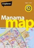
Manama Street Plan
Manama on a GPS-compatible street plan from the Dubai-based Explorer Publishing, presenting on one side the city at 1:15, 000, plus on the reverse a wider area including the Bahrain International Airport at 1:32, 000. All place names are in the Latin alphabet only.On one side is a plan of the city at 1:15, 000 highlighting its network of main traffic arteries. The plan shows names of neighbourhoods, plus of main and selected connecting streets. Various facilities and places of interest are named and/or marked by symbols, including hotels and restaurants, banks, embassies and consulates, etc. Coverage includes access to the Bahrain International Airport. Accompanying index lists neighbourhoods, shopping, hotels, etc. The plan has a 1km UTM grid.On the reverse a wider area of
Manama, including the Bahrain International Airport and the Amwaj Island, is presented at 1:32, 000 with a 2-km UTM grid. Also provided is a small overview road map of Bahrain. Map legend and names of facilities are in English.
Manama, including the Bahrain International Airport and the Amwaj Island, is presented at 1:32, 000 with a 2-km UTM grid. Also provided is a small overview road map of Bahrain. Map legend and names of facilities are in English.

Product Description
Reviews/Comments
Add New
Vouchers
No voucher codes found.
Do you know a voucher code for this product or supplier? Add it to Insights for others to use.
Do you know a voucher code for this product or supplier? Add it to Insights for others to use.
 Denmark