
 United Kingdom
 France
 Germany
 Netherlands
 Sweden
 USA
USA
 Italy
Italy
 Spain
Spain
More From Contributor

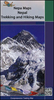


Manaslu And Ganesh Himals (WATERPROOF Edition)
Manaslu and Ganesh Himals, map no. 106, at 1:125, 000 on a waterproof and tear-resistant trekking map from the Himalayan MapHouse in their series covering the whole of northern Nepal. The map shows the northern part of the Tsum Valley and the surrounding mountains including Ganesh (Yangra) as an inset and highlights treks north of Arughat Bazar and Besisahar, including the Manaslu Circuit, Ganesh Himal and Tsum Valley treks, Himal Chuli Base Camp Trek and Rupina La Trek. Also highlighted are the relevant sections of the GHT Cultural Trail and the GHT High Route. Contours are at 80m intervals. Route profile shows the Manaslu and Ganesh section of the GHT High Route between Dharapani and Tipling.Cartography in these waterproof editions, first published in 2011, is identical to what
Himalayan MapHouse use in most maps in their other series, published under the Nepa Maps imprint. Contours are at intervals of 80m or 40m (please check individual descriptions), with relief shading plus colouring to show different types of terrain or vegetation. The maps show names of numerous chains, peaks glaciers, valleys, rivers, lakes, etc.Main trekking routes are prominently highlighted, as are selected settlements along them, indicating where tourist accommodation and other services are provided. Also clearly marked are campsites or base camps and various places of interest. The maps also show other local trekking paths, often providing variants or shortcuts to the main routes. The maps are not indexed. Latitude and longitude coordinates are given as margin ticks at 5
Himalayan MapHouse use in most maps in their other series, published under the Nepa Maps imprint. Contours are at intervals of 80m or 40m (please check individual descriptions), with relief shading plus colouring to show different types of terrain or vegetation. The maps show names of numerous chains, peaks glaciers, valleys, rivers, lakes, etc.Main trekking routes are prominently highlighted, as are selected settlements along them, indicating where tourist accommodation and other services are provided. Also clearly marked are campsites or base camps and various places of interest. The maps also show other local trekking paths, often providing variants or shortcuts to the main routes. The maps are not indexed. Latitude and longitude coordinates are given as margin ticks at 5
 "Pin It")
Product Description
Reviews/Comments
Add New
Vouchers
No voucher codes found.
Do you know a voucher code for this product or supplier? Add it to Insights for others to use.
Do you know a voucher code for this product or supplier? Add it to Insights for others to use.
 Denmark