
 United Kingdom
 France
 Germany
 Netherlands
 Sweden
 USA
USA
 Italy
Italy
 Spain
Spain
More From Contributor


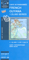
Mana IGN Map 4703
One of the titles in the topographic survey of the coastal part of French Guiana, published as an extension of IGN’s survey of France to its overseas departments. Contours are at 5m intervals and the maps indicate 13 different types of vegetation and land use, including rain forest, brushwood, savanna, high and low mangrove, rice fields, orchards and plantations, etc. The extent of changes in the coastline in the recent decades is indicated. The maps have a UTM grid and latitude/longitude lines at intervals of 5’. Map legend includes English.

Product Description
Reviews/Comments
Add New
Vouchers
No voucher codes found.
Do you know a voucher code for this product or supplier? Add it to Insights for others to use.
Do you know a voucher code for this product or supplier? Add it to Insights for others to use.
 Denmark