
 United Kingdom
 France
 Germany
 Netherlands
 Sweden
 USA
USA
 Italy
Italy
 Spain
Spain
More From Contributor

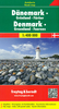


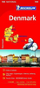

Denmark Hallwag Road Map
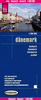
Detailed touring map of Denmark, also south-western Sweden between Malmo and Gothenburg and extending south to Hamburg and Bremenhaven and covering the whole of the Baltic coast of Germany.The map shows seven different kind of roads, with road names and junction numbers, intermediate driving distances in km, petrol stations, restaurants and motels along main roads.Railways, ferry lines and shipping routes, airports and administrative boundaries are also marked alongside spot elevation in metres, wood, heath and recommended beaches. A number of symbols also indicates places of interests, viewpoints, notable buildings and ruins, monuments and campsites.The map also includes a special ”Distoguide” incorporated into the map cover, showing at a glance road distances between
several Swedish cities.Map index is in a separate booklet attached to the cover.All texts are in six different European languages including English.
several Swedish cities.Map index is in a separate booklet attached to the cover.All texts are in six different European languages including English.

Product Description
Reviews/Comments
Add New
Intelligent Comparison
Archived Product

Germany Hallwag Road Map Stanfords
£12.99
Archived Product

China Hallwag Road Map Stanfords
£13.99
Archived Product

Canada Hallwag Road Map Stanfords
£13.99
Archived Product

Sweden Hallwag Road Map Stanfords
£12.99
Archived Product

Finland Hallwag Road Map Stanfords
£12.99
Archived Product

Ireland Hallwag Road Map Stanfords
£12.99
Archived Product

Italy Hallwag Road Map Stanfords
£12.99
Archived Product

Germany North Hallwag Road Map Stanfords
£12.99
Vouchers
No voucher codes found.
Do you know a voucher code for this product or supplier? Add it to Insights for others to use.
Do you know a voucher code for this product or supplier? Add it to Insights for others to use.
 Denmark