
 United Kingdom
 France
 Germany
 Netherlands
 Sweden
 USA
USA
 Italy
Italy
 Spain
Spain
More From Contributor


Denmark F&B
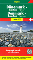
Denmark at 1:400, 000 on a road map from Freytag& Berndt with an index in a separate booklet attached to the map cover which also contains street plans of central Copenhagen, Aarhus and Odense. Coverage includes the south-western coast of Sweden up to Gothenburg. Road network clearly shows motorway services, highlights toll roads and scenic or special tourist routes, and gives driving distances on main and selected secondary routes. Also shown are ferry routes, both within Denmark and with Swedish ports. Symbols indicate various facilities and places of interest including campsites and youth hostels, historical and cultural sites, nature reserves, etc. The map has latitude and longitude lines at 30’ intervals. The index, in a separate booklet attached to the map cover, lists
locations with their postcodes. Map legend includes English.On the reverse are maps of the Faroe Islands (1:400, 000) and Greenland (1:4, 000, 000); locations on these two maps are not included in the index.
locations with their postcodes. Map legend includes English.On the reverse are maps of the Faroe Islands (1:400, 000) and Greenland (1:4, 000, 000); locations on these two maps are not included in the index.

Product Description
Reviews/Comments
Add New
Intelligent Comparison
Archived Product
Denmark Stanfords
£11.19
Archived Product
Denmark Stanfords
£11.99
Archived Product
Denmark Stanfords
£11.99
Archived Product
Denmark Stanfords
£9.50
Archived Product
Denmark Stanfords
£9.95
Archived Product

Denmark Stanfords
£11.99
Vouchers
No voucher codes found.
Do you know a voucher code for this product or supplier? Add it to Insights for others to use.
Do you know a voucher code for this product or supplier? Add it to Insights for others to use.
 Denmark