
 United Kingdom
 France
 Germany
 Netherlands
 Sweden
 USA
USA
 Italy
Italy
 Spain
Spain
More From Contributor

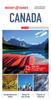


Canada Hallwag Road Map
Detailed touring map of southern Canada showing six different kinds of roads, with road names, intermediate driving distances in km an miles, pick high and passes.Railways, ferry lines and airports are also marked alongside national and international boundaries, time zones boundaries, restricted areas, national parks, indian reserves. Also indicated are places/objects of interests, ancient and wells.The map also includes a special ”Distoguide” incorporated into the map cover, showing at a glance road distances between several Canadian cities.Map index is in a separate booklet attached to the cover.All texts are in eight different languages including English.

Product Description
Reviews/Comments
Add New
Intelligent Comparison
Archived Product

China Hallwag Road Map Stanfords
£13.99
Archived Product

Finland Hallwag Road Map Stanfords
£12.99
Archived Product

Ireland Hallwag Road Map Stanfords
£12.99
Archived Product

France Hallwag Road Map Stanfords
£12.99
Archived Product

Germany Hallwag Road Map Stanfords
£12.99
Archived Product

Italy Hallwag Road Map Stanfords
£12.99
Archived Product

USA Hallwag Road Map Stanfords
£13.99
Archived Product

Netherlands Hallwag Road Map Stanfords
£12.99
Vouchers
No voucher codes found.
Do you know a voucher code for this product or supplier? Add it to Insights for others to use.
Do you know a voucher code for this product or supplier? Add it to Insights for others to use.
 Denmark