
 United Kingdom
 France
 Germany
 Netherlands
 Sweden
 USA
USA
 Italy
Italy
 Spain
Spain
More From Contributor


Canada FastTrack
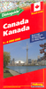
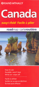
Canada Easy-to-Fold at 1:12, 500, 000 from the Canadian Cartographics Corporation; the map is laminated, so waterproof and tear-resistant and can be written on with suitable marker pens, and provides a very basic overview of the country and its road network, plus a list of main places of interest, a distance table and a map of USA.On one side is a general map of Canada showing its division into provinces and time zones. Coverage extends north just beyond Baffin Island. Topography is shown by relief shading, with names of main mountain ranges, rivers and lakes. Several national or provincial parks are highlighted. The map is indexed. Accompanying panels provided facts and figures about the country. On the reverse are bilingual lists of main places to visit in each province, a
comprehensive distance table, plus an overview map of USA showing the main highways.*Please note:* following a number changes among Canadian cartographic publishers maps previously published by MapArt Publishing may now be available under one of the following imprints: MapArt, Canadian Cartographics Corporation or JDM Géo Inc. Within a series, therefore, some titles may still be published as MapArt whilst others will be available as Canadian Cartographics Corporation or JDM Géo Inc.
comprehensive distance table, plus an overview map of USA showing the main highways.*Please note:* following a number changes among Canadian cartographic publishers maps previously published by MapArt Publishing may now be available under one of the following imprints: MapArt, Canadian Cartographics Corporation or JDM Géo Inc. Within a series, therefore, some titles may still be published as MapArt whilst others will be available as Canadian Cartographics Corporation or JDM Géo Inc.

Product Description
Reviews/Comments
Add New
Intelligent Comparison
Archived Product
Calgary FastTrack Stanfords
£10.99
Archived Product
Canada East Stanfords
£8.99
Vouchers
No voucher codes found.
Do you know a voucher code for this product or supplier? Add it to Insights for others to use.
Do you know a voucher code for this product or supplier? Add it to Insights for others to use.
 Denmark