
 United Kingdom
 France
 Germany
 Netherlands
 Sweden
 USA
USA
 Italy
Italy
 Spain
Spain
More From Contributor


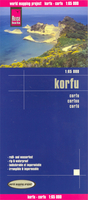
Corfu Reise Know-How
Corfu on clear, waterproof and tear-resistant, indexed map with topographic and tourist information, published by Reise Know-How as part of their highly acclaimed World Mapping Project. Topography is shown by altitude colouring with contours and spot heights, and includes seasonal streams. Road network shows local roads and tracks, gives driving distances and indicates locations of petrol stations. Ferry routes to Igoumenitsa, Albania, Italy and the nearby Paxos are shown on a separate inset which presents Corfu with the adjoining mainland where campsites are also marked.Symbols show locations of various places in interest, including viewpoints, beaches, archaeological sites, churches and monasteries, campsites, harbours and marinas, etc. Names of towns and villages are in
both scripts on the map and in the accompanying index; geographical information and places of interest are in Roman alphabet only. The map has both a UTM grid and latitude and longitude at intervals of 5’. Map legend includes English. *”World Mapping Project”* is an extensive series of maps at varying scales, aiming to provide coverage of countries and regions worldwide using clear, well presented cartography with both topographic and tourist information.
both scripts on the map and in the accompanying index; geographical information and places of interest are in Roman alphabet only. The map has both a UTM grid and latitude and longitude at intervals of 5’. Map legend includes English. *”World Mapping Project”* is an extensive series of maps at varying scales, aiming to provide coverage of countries and regions worldwide using clear, well presented cartography with both topographic and tourist information.

Product Description
Reviews/Comments
Add New
Intelligent Comparison
Archived Product
Crimea Reise Know-How Stanfords
£10.50
Archived Product
Borneo Reise Know-How Stanfords
£10.50
Archived Product
Georgia Reise Know-How Stanfords
£11.50
Archived Product
Brazil Reise Know-How Stanfords
£10.50
Archived Product

Poland Reise Know-How Stanfords
£10.50
Archived Product
Istria Reise Know-How Stanfords
£10.50
Archived Product
Ukraine Reise Know-How Stanfords
£10.50
Archived Product
Yucatan Reise Know-How Stanfords
£11.50
Vouchers
No voucher codes found.
Do you know a voucher code for this product or supplier? Add it to Insights for others to use.
Do you know a voucher code for this product or supplier? Add it to Insights for others to use.
 Denmark