More From Contributor
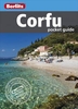
£4.99
Corfu in the Pocket Guide series from Berlitz; a collection of handy, pocket-sized guides dedicated to an extensive range of cities, regions & countries worldwide. Written in narrative form, individual guides explore the history, main sights & attractions, food & drink, accommodation & local culture of the destination in detail. Each Berlitz pocket guide has a similar format, with colour-coded sections helping readers locate information quickly in addition to distinctive chapters exploring the city or region. An introduction outlines the destination for visitors & a section dedicated to 'A Brief History' actually explores the area in relative depth. A where to go chapter is organized by region & city & is written in prose form with references to individual sites highlighted in bold for clarity. There are also further suggestions on where & when to eat. Recommendations for leisure activities in the region, including sport, nightlife & shopping, are also provided & tailored accordingly for each destination. Handy travel tips are listed alphabetically in a dedicated section, providing practical guidance & helping visitors make the most of their stay. The main hotels, particularly for cities, are also listed in an accommodation section, offering a brief overview with approximate price bandings & relevant contact details. ...
Archived Product
£4.49
Corfu in the Pocket Guide series from Berlitz; a collection of handy, pocket-sized guides dedicated to an extensive range of cities, regions & countries worldwide. Written in narrative form, individual guides explore the history, main sights & attractions, food & drink, accommodation & local culture of the destination in detail. Each Berlitz pocket guide has a similar format, with colour-coded sections helping readers locate information quickly in addition to distinctive chapters exploring the city or region. An introduction outlines the destination for visitors & a section dedicated to 'A Brief History' actually explores the area in relative depth. A where to go chapter is organized by region & city & is written in prose form with references to individual sites highlighted in bold for clarity. There are also further suggestions on where & when to eat. Recommendations for leisure activities in the region, including sport, nightlife & shopping, are also provided & tailored accordingly for each destination. Handy travel tips are listed alphabetically in a dedicated section, providing practical guidance & helping visitors make the most of their stay. The main hotels, particularly for cities, are also listed in an accommodation section, offering a brief overview with approximate price bandings & relevant contact details. ...
Archived Product
£5.99
Berlitz Pocket Guide Corfu gives you reliable, user-friendly detail with colour photography to uncover Greece`s pretty Emerald Isle: from elegant Corfu Town with its lovely, Venetian architecture & its relics of British rule, cricket included, to sunny beaches, the Achilleion Palace, Lawrence Durrell`s beloved White House, & a springtime abundance of wild flowers. Handy maps on the cover flaps help you get around. Inside Corfu Pocket Guide: Where To Go details all the key sights in the country, while handy maps on the cover flaps help you find your way around, & are cross-referenced to the text. Features top 10 Attractions gives a run-down of the best sights to take in on your trip. Perfect Tour provides an itinerary of the isl&. What To Do is a snapshot of ways to spend your spare time, from shopping to working your way around stylish bars. Essential information on Greek culture, including a brief history of the Isl&. Eating Out covers the countries best cuisine. Curated listings of the best hotels & restaurants. A-Z of all the practical information you`ll need. ...
Archived Product
£10.50
Corfu on clear, waterproof & tear-resistant, indexed map with topographic & tourist information, published by Reise Know-How as part of their highly acclaimed World Mapping Project. Topography is shown by altitude colouring with contours & spot heights, &

Includes::
seasonal streams. Road network shows local roads & tracks, gives driving distances & indicates locations of petrol stations. Ferry routes to Igoumenitsa, Albania, Italy & the nearby Paxos are shown on a separate inset which presents Corfu with the adjoining mainland where campsites are also marked. Symbols show locations of various places in interest, including viewpoints, beaches, archaeological sites, churches & monasteries, campsites, harbours & marinas, etc. Names of towns & villages are in both scripts on the map & in the accompanying index; geographical information & places of interest are in Roman alphabet only. The map has both a UTM grid & latitude & longitude at intervals of 5’. Map legend

Includes::
English. *” World Mapping Project”* is an extensive series of maps at varying scales, aiming to provide coverage of countries & regions worldwide using clear, well presented cartography with both topographic & tourist information.


...
Archived Product
£9.99
Corfu in the AA Spiral Guides series; comprising a selection of titles exploring a wide range of cities, regions & countries in a handy, spiral loose-leaf format. Fold-out flaps at the front & back of each title give an overview of the main regions covered, with page numbers so visitors can locate their destination easily. Each guide explores the destination geographically by region or area & provides the essential information for the main sites & attractions in addition to a recommended tour of each area by car. An introductory section - ...
Archived Product
£8.99
Corfu Tour & Trail Super-Durable Map is the most detailed, accurate, toughest, large scale map of the island that you can buy. Super-Durable Maps now come with a 2 year adventurous use wear & tear guarantee, see Discovery Walking Guides website for details. Our large 1:40, 000 scale produces a double sided map sheet of 840mm by 680mm; big enough to show masses of detail but compact enough to use in the car or on the trail. Corfu North is on the facing sheet of the map with Corfu South on the reverse side, including a generous overlap between the two sides. Our special concertina map fold means your map is easy to unfold, & more importantly easy to refold back to its pocket size. You get the most detailed map of Corfu that is produced including our ` Tour & Trail` level of detail ranging from major roads to secondary roads to minor roads to streets & narrow country roads, plus dirt roads & walking trails. We have a new method of highlighting the full Corfu Trail, including its options, with the trails, tracks, lanes & roads making up the Corfu Trail being outlined in green. This makes it easier to identify the Corfu Trail on the map & easier to find it on the ground. Altitude background colouring is designed to clearly show the altitude range when traveling across the island by car or on foot.100 metre & 20 metre contours are clearly shown on the map along with a large number of individual height points. Tour & Trail attention to detail is legendary as is our useful symbol range including miradors, picnic areas, petrol stations, bar/restaurants & parking areas where you can pull off the road safely. New for our Corfu Tour & Trail Super-Durable Map we have introduced special Place-Name Plaques for Tripadvisor`s most popular destinations making them easy to find. For adventurers on foot Tour & Trail Maps are researched & designed by hikers for use by hikers. Our comprehensive gps ground surveys produce the best road mapping available but the value of this on the ground research becomes even more important when you leave the tarmac. When you buy the Corfu Tour & Trail Super-Durable Map you will find instructions on the map of how to receive the Custom Map digital edition for Garmin users for free, simply email the address on the map & receive an email containing the download link. Super-Durable editions are printed with 100% oxygenation inks on Polyart by the UK`s leading map printer. This produces a Super-Durable Map that feels like silk but will stand up to the roughest treatment of outdoor adventuring & yet fold up like new at the end of your adventure. Quite simply Corfu Tour & Trail Super-Durable Map is the most detailed, accurate, toughest, large scale Corfu map that you can buy. Super-Durable maps are 100% recyclable. ...
Archived Product
£6.50
Topographic coverage of mainland Spain at 1:25, 000 published by the Centro Nacional de Información Geograficá, the country’s civilian survey organization. The maps have contours at 10m intervals & colouring and/or graphics to show different types of vegetation or land use. Boundaries of national parks & other protected areas are marked. In addition to all the usual information shown on topographic maps at this scale, detailed presentation of the road & rail networks, rural tracks & paths, etc, the maps also show campsites. The maps have a 1-km UTM grid, with margin ticks for latitude & longitude at 1` intervals. Map legend is in Spanish only.PLEASE NOTE: our grid for the whole of Spain is in preparation
- in the meantime, for areas other than those shown on the attached grid please use CNIG’s topographic survey at 1:50, 000 by searching for ‘SI00000832’. Each 25K map covers one quarter of the corresponding 50K map, with the numbering system: I = NW quarter, II = NE quarter, III = SW quarter & IV = SE quarter. CNIG maps in the Provincial Road Maps series at 1:200, 000 are overprinted with the grid for the 1:50, 000 survey & can be used to see the area covered by each 50K or 25K title in more detail. To see the list of titles in this series please click on the series grid
- for map numbers not yet listed on our website please contact us by email.

...
Archived Product
£1.99
Jill Dudley writes about the clash of St. Paul`s concept of love with the sexual pleasures which the pagans enjoyed at the great temple of Aphrodite on Acrocorinth. She describes how the Apostle spent his time at nearby Old Corinth observing, preaching & converting, & why he wrote his Letters to the Corinthians. It is as it says on the back cover of the booklet: All you need to know about the sacred site, its myths, legends & its gods. ...
Archived Product
£6.50
Topographic coverage of mainland Spain at 1:25, 000 published by the Centro Nacional de Información Geograficá, the country’s civilian survey organization. The maps have contours at 10m intervals & colouring and/or graphics to show different types of vegetation or land use. Boundaries of national parks & other protected areas are marked. In addition to all the usual information shown on topographic maps at this scale, detailed presentation of the road & rail networks, rural tracks & paths, etc, the maps also show campsites. The maps have a 1-km UTM grid, with margin ticks for latitude & longitude at 1` intervals. Map legend is in Spanish only.PLEASE NOTE: our grid for the whole of Spain is in preparation
- in the meantime, for areas other than those shown on the attached grid please use CNIG’s topographic survey at 1:50, 000 by searching for ‘SI00000832’. Each 25K map covers one quarter of the corresponding 50K map, with the numbering system: I = NW quarter, II = NE quarter, III = SW quarter & IV = SE quarter. CNIG maps in the Provincial Road Maps series at 1:200, 000 are overprinted with the grid for the 1:50, 000 survey & can be used to see the area covered by each 50K or 25K title in more detail. To see the list of titles in this series please click on the series grid
- for map numbers not yet listed on our website please contact us by email.

...
Archived Product
£7.50
Cork on an indexed street plan at 1:15, 000 from the Ordnance Survey of Irel&. An enlargement shows the city centre in greater detail, highlighting 34 places of interest and/or facilities. The index is in a separate booklet attached to the map cover.OSI street plans highlight main traffic arteries in each town: national primary & secondary routes, regional roads & main streets, with one way & pedestrianized streets. Colouring indicates public buildings, highlighting the more important ones, railway/bus stations & medical centres. A range of symbols indicate various facilities, including An ...
Archived Product

Corfu SUPERCEDED

The highly successful Globetrotter Travel Series, which includes Travel Guides, Travel Maps, Road Atlases, Best Of Pocket Guides and In Your Pocket Language Guides, presently covers more than 90 destinations worldwide. The Packs are excellent value, including both a guidebook and a soft cover version of the fold-out Globetrotter map of the region, in a printed plastic wallet. The handy pocket-size guide is packed with useful information, tips and recommendations, accompanied by color photographs, charts and maps for the first-time traveler who wants to experience the major highlights that Corfu has to offer. The fold-out map of Corfu is ideal for tourists and visitors.
RIP - This product is no longer available on our network. It was last seen on 25.09.2019

This page now acts as a permanent archive for this product. Add more information using the comments box below to ensure it can still be found by future generations.

Use our search facility to see if it is available from an alternative contributor.
  • Availability: Out Of Stock
  • Supplier: Stanfords
  • SKU: 9781847733757
Availability: In Stock
£8.99

Product Description

The highly successful Globetrotter Travel Series, which

Includes::
Travel Guides, Travel Maps, Road Atlases, Best Of Pocket Guides & In Your Pocket Language Guides, presently covers more than 90 destinations worldwide. The Packs are excellent value, including both a guidebook & a soft cover version of the fold-out Globetrotter map of the region, in a printed plastic wallet. The handy pocket-size guide is packed with useful information, tips & recommendations, accompanied by color photographs, charts & maps for the first-time traveler who wants to experience the major highlights that Corfu has to offer. The fold-out map of Corfu is ideal for tourists & visitors.

Reviews/Comments

Add New

Intelligent Comparison

Oooops!
We couldn't find anything!
Perhaps this product's unique.... Or perhaps we are still looking for comparisons!
Click to bump this page and we'll hurry up.

Price History

Vouchers

No voucher codes found.
Do you know a voucher code for this product or supplier? Add it to Insights for others to use.

Facebook

Jargon Buster

Plastic - A generic term for a synthetic product used in the manufacture of products
soft - A descriptive word for an item/sound which is gentle to the touch or ears
Size - is the measurement of how big an object is in space.
Language - the method of communication used in different areas. Humans and computers have many different languages.
Road - a manmade lane or a path that is used to speed up travel.
Experience - To gain further knowledge by practising.
Pocket - A bag shaped insert in clothing used to carry items
Ideal - Something that satisfies a perfect criteria.
Language - The way humans communicate either written and spoken.

Supplier Information

Stanfords
Stanfords was established in 1853 and opened their iconic Covent Garden flagship store in 1901. They have become the top retailer of maps, travel books and accessories in the UK and arguably offer the largest selection of maps and travel books worldwide. Famous names such as Captain Robert Falcon Scott, Ranulph Fiennes and Michael Palin have purchased from Stanfords. They now have a shop in Bristol and both stores together with other venues operate a calendar of events including talks, book signings and exhibitions. As a specialist map retailer, the map selection is comprehensive and includes road maps, street maps and walking maps from worldwide destinations, as well as a selection of world atlases and wall maps. Books include travel guides and travel literature. Stanfords also stock globes, from miniatures made of blue marble to magnificent floor-standing globes. The website features a selection of interesting articles on travel topics.
Page Updated: 2023-11-12 20:15:36

Community Generated Product Tags

Oh No! The productWIKI community hasn't generated any tags for this product yet!
Menu