
 United Kingdom
 France
 Germany
 Netherlands
 Sweden
 USA
USA
 Italy
Italy
 Spain
Spain
More From Contributor


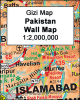
Pakistan Gizi Map
Pakistan and the whole of Afghanistan at 1:2, 000, 000 from Gizi Map with bold altitude colouring clearly showing the physical geography of these countries and the surrounding region, plus tourist and administrative information.The map shows the road and rail networks, highlighting the course of the different variants of the Silk Route and other locations of historical interest. The map also indicates local administrative boundaries and names of the provinces. All place names are in the Latin alphabet only.Topography is presented by bold altitude colouring with spot heights, plus graphic indicating deserts, swamps and salt flats, etc, and the map has plenty of names of mountain ranges, valleys, and various other geographical features. Latitude and longitude lines are drawn at 1°
intervals. The index placed next to the map lists only locations within Pakistan. Map legend includes English.Please note: this title is also available as a wall map.
intervals. The index placed next to the map lists only locations within Pakistan. Map legend includes English.Please note: this title is also available as a wall map.

Product Description
Reviews/Comments
Add New
Intelligent Comparison
Archived Product

Turkmenistan Gizi Map Stanfords
£9.99
Archived Product

Mauritania Gizi Map Stanfords
£9.99
Archived Product
Pakistan Wall Map Stanfords
£13.50
Archived Product
Iran Gizi Map Stanfords
£9.99
Archived Product

Mali Gizi Map Stanfords
£9.99
Archived Product
Somalia Gizi Map Stanfords
£9.99
Archived Product

Kyrgyzstan Gizi Map Stanfords
£9.99
Archived Product

Saint Lucia Gizi Map Stanfords
£9.99
Vouchers
No voucher codes found.
Do you know a voucher code for this product or supplier? Add it to Insights for others to use.
Do you know a voucher code for this product or supplier? Add it to Insights for others to use.
 Denmark