
 United Kingdom
 France
 Germany
 Netherlands
 Sweden
 USA
USA
 Italy
Italy
 Spain
Spain
More From Contributor
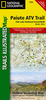

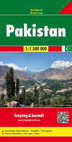
Pakistan
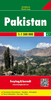
Pakistan at 1:1, 500, 000 from Nelles Verlag on a double-sided, smaller size sheet offering a convenient format for use when travelling, with street plans Karachi, Lahore and Peshawar, all highlighting places of interest, etc.The map divides the country north/south, with a small overlap between the sides. The Pakistani part of Jammu and Kashmir is shown as an inset, indicating the disputed boundaries with India and China.Vivid relief shading with spot heights and names of mountain ranges and peaks presents the topography. Road network distinguishes between highways in good and poor condition and includes partly surfaced roads and cart tracks, with distances shown on main routes. Railway lines and local airports are included, and the map also shows internal administrative
boundaries with names of the provincies. National parks or protected areas and numerous places of interest are prominently marked. Latitude and longitude margin ticks are at 1
boundaries with names of the provincies. National parks or protected areas and numerous places of interest are prominently marked. Latitude and longitude margin ticks are at 1
Product Description
Reviews/Comments
Add New
Intelligent Comparison
Archived Product
Pakistan F&B Stanfords
£10.99
Archived Product
Tajikistan Stanfords
£14.95
Archived Product

Pasta Stanfords
£9.99
Archived Product
Pakistan ITMB Stanfords
£9.99
Vouchers
No voucher codes found.
Do you know a voucher code for this product or supplier? Add it to Insights for others to use.
Do you know a voucher code for this product or supplier? Add it to Insights for others to use.
 Denmark