
 United Kingdom
 France
 Germany
 Netherlands
 Sweden
 USA
USA
 Italy
Italy
 Spain
Spain
More From Contributor

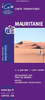


Mauritania Gizi Map
Mauritania and Western Sahara with excellent topographic information on an indexed map with a street plan of central Nouakchot. Vivid altitude colouring with graphics for deserts, flood plains and salt flats shows the terrain. Oases, water wells and numerous spot heights are marked and the map provides plenty of names of geographical features: peaks, mountain chains and rock outcrops, plains, etc. Road network shows distances on main roads and includes dirt tracks. The map also shows locations of local airfields and the route of the iron ore railway line from the mines at Zouérat to the coast. Symbols highlight various places of tourist interest including world heritage sites, forts and archaeological remains, national parks and protected areas, beaches, etc.Names of main towns
and important geographical features are also given in Arabic. Internal administrative boundaries are shown with names of the provinces. The map had latitude and longitude lines at intervals of 1º. Map legend includes English. The index lists separately locations in Mauritania, Western Sahara, plus the adjoining regions of Mali and Senegal. Also included is a plan of central Nouakchott indicating main public buildings, hotels and various facilities.Please note: this title is also available as a wall map.
and important geographical features are also given in Arabic. Internal administrative boundaries are shown with names of the provinces. The map had latitude and longitude lines at intervals of 1º. Map legend includes English. The index lists separately locations in Mauritania, Western Sahara, plus the adjoining regions of Mali and Senegal. Also included is a plan of central Nouakchott indicating main public buildings, hotels and various facilities.Please note: this title is also available as a wall map.

Product Description
Reviews/Comments
Add New
Intelligent Comparison
Archived Product

Mauritania Wall Map Stanfords
£13.50
Archived Product

Pakistan Gizi Map Stanfords
£9.99
Archived Product
Iran Gizi Map Stanfords
£9.99
Archived Product

Saudi Arabia Gizi Map Stanfords
£9.99
Archived Product

Turkmenistan Gizi Map Stanfords
£9.99
Archived Product

Mali Gizi Map Stanfords
£9.99
Archived Product

Syria Gizi Map Stanfords
£9.99
Archived Product

Mauritania ITMB Stanfords
£9.99
Vouchers
No voucher codes found.
Do you know a voucher code for this product or supplier? Add it to Insights for others to use.
Do you know a voucher code for this product or supplier? Add it to Insights for others to use.
 Denmark