
 United Kingdom
 France
 Germany
 Netherlands
 Sweden
 USA
USA
 Italy
Italy
 Spain
Spain
More From Contributor
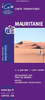


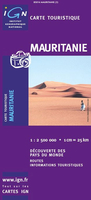
Mauritania ITMB
Indexed map of the country with a plan of Nouakchott and coverage of the whole of Western Sahara. Altitude colouring (in feet) with occasional spot heights is complemented by names of main hill ranges, plus cliffs or scarps within the Saharan region. Both permanent and intermittent streams and creeks are marked, as wells as dry lakes or salt flats, and desert areas are indicated. Also shown are numerous wells, many with names. Road network includes minor roads and tracks, with approximate driving distances between selected points and location of petrol stations. The railway line from Nouadhibou to Zouerat is shown, as well as local aerodromes. Local administrative boundaries are marked, with names of districts, and national parks are shown. Symbols indicate border crossings,
antiquities, places of interest, various types of accommodation, hospital and medical facilities, etc. Latitude and longitude grid lines are drawn at 2º30` intervals.The maps includes a simple street plan of Nouakchott, showing main streets, a glossary of geographic terms, and an index listing only main towns and villages.
antiquities, places of interest, various types of accommodation, hospital and medical facilities, etc. Latitude and longitude grid lines are drawn at 2º30` intervals.The maps includes a simple street plan of Nouakchott, showing main streets, a glossary of geographic terms, and an index listing only main towns and villages.

Product Description
Reviews/Comments
Add New
Intelligent Comparison
Archived Product
Mauritania Stanfords
£10.99
Archived Product

Manila ITMB Stanfords
£9.99
Archived Product
Malaysia ITMB Stanfords
£9.99
Archived Product
Manitoba ITMB Stanfords
£9.99
Archived Product
Pakistan ITMB Stanfords
£9.99
Archived Product
Tanzania ITMB Stanfords
£9.99
Archived Product

Mauritania Gizi Map Stanfords
£9.99
Archived Product

Mauritania Wall Map Stanfords
£13.50
Vouchers
No voucher codes found.
Do you know a voucher code for this product or supplier? Add it to Insights for others to use.
Do you know a voucher code for this product or supplier? Add it to Insights for others to use.
 Denmark