
 United Kingdom
 France
 Germany
 Netherlands
 Sweden
 USA
USA
 Italy
Italy
 Spain
Spain
More From Contributor


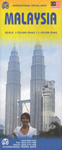
Malaysia ITMB
Malaysia on a double-sided, indexed map from ITMB showing the western, peninsular part at 1:750, 000, with Sarawak and Sabah at 1:1, 100, 000, plus large clear, street plans of central Kuala Lumpur, Kuching, Bandar Seri Bengawan and Kota Kinabalu, and an enlargement of the Mount Kinabalu Trail.Altitude colouring with elevation in feet shows the topography, and the map has numerous spot heights, particularly in the mountainous regions. Graphics indicate swamp areas and sand dunes. National parks and wildlife reserves are highlighted. Road network indicates toll motorways and includes selected local tracks. Railway lines are included and domestic airports are marked. The map also shows internal administrative boundaries and names of the provinces. Symbols highlight various places
of interest. Latitude and longitude lines are drawn at 30’ intervals in Peninsular Malaysia and at 1° intervals in Borneo. Each side has a separate index. The map also has large, very clear street plans of central Kuala Lumpur, Kuching, Bandar Seri Bengawan and Kota Kinabalu, indicating numerous hotels, various sights and facilities, etc. An enlargement at 1:50, 000 approx and with contours at 500 feet intervals presents the trail to the summit of Mount Kinabalu.
of interest. Latitude and longitude lines are drawn at 30’ intervals in Peninsular Malaysia and at 1° intervals in Borneo. Each side has a separate index. The map also has large, very clear street plans of central Kuala Lumpur, Kuching, Bandar Seri Bengawan and Kota Kinabalu, indicating numerous hotels, various sights and facilities, etc. An enlargement at 1:50, 000 approx and with contours at 500 feet intervals presents the trail to the summit of Mount Kinabalu.

Product Description
Reviews/Comments
Add New
Intelligent Comparison
Archived Product

Mali ITMB Stanfords
£9.99
Archived Product
Malaysia F&B Stanfords
£10.99
Archived Product
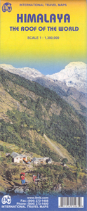
Himalaya ITMB Stanfords
£9.99
Archived Product
Malaysia Stanfords
£7.99
Archived Product
Malaysia Stanfords
£9.95
Archived Product
Malaysia Stanfords
£9.95
Archived Product
Malaysia Stanfords
£9.50
Archived Product
Malaysia Stanfords
£7.99
Vouchers
No voucher codes found.
Do you know a voucher code for this product or supplier? Add it to Insights for others to use.
Do you know a voucher code for this product or supplier? Add it to Insights for others to use.
 Denmark