
 United Kingdom
 France
 Germany
 Netherlands
 Sweden
 USA
USA
 Italy
Italy
 Spain
Spain
More From Contributor


Malaysia F&B
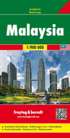
Malaysia on a double-sided, indexed map from Freytag & Berndt, covering both parts of the country at the same scale of 1:900, 000; on one side Peninsular Malaysia, with Sarawak and Sabah on the reverse. Very effective relief shading with spot heights and graphics for swamps or mangrove areas and coral reefs provide good representation of the country’s topography.Road network includes selected local tracks; intermediate distances are given on main routes. Railways, local airports and ferry routes are shown, as well as the country’s internal administrative boundaries with names of the provinces. National parks and other protected areas are highlighted, and icons mark locations of various places of interest, including temples, beaches, caves, etc. The map has a latitude and
longitude grid at intervals of 1º and an index. Map legend includes English.
longitude grid at intervals of 1º and an index. Map legend includes English.

Product Description
Reviews/Comments
Add New
Vouchers
No voucher codes found.
Do you know a voucher code for this product or supplier? Add it to Insights for others to use.
Do you know a voucher code for this product or supplier? Add it to Insights for others to use.
 Denmark