
 United Kingdom
 France
 Germany
 Netherlands
 Sweden
 USA
USA
 Italy
Italy
 Spain
Spain
More From Contributor


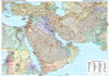
Middle East Reise-Know-How Map
The northern part of the Middle East at 1:1, 200, 000 on a double-sided, indexed, waterproof and tear-resistant road map published by Reise Know-How as part of their highly acclaimed World Mapping Project. The map is double-sided to provide the best balance between a good scale and a convenient size sheet. Coverage on one side extends from Cairo and the Sinai Peninsula to include all of Israel, Lebanon and Jordan, most of Syria as well as Cyprus and the south-western coastline of Turkey. On the reverse is the easternmost part of Syria plus Iraq and Kuwait. Place names are in Latin alphabet, with names of larger towns are given in Arabic.Roads (from motorways to selected seasonal tracks) and railways are easy to see on a clear base which shows the area’s topography by altitude
colouring with contours, spot heights, mountain passes and names of its numerous mountain ranges, deserts, etc. National parks and protected areas highlighted. Presentation of international boundaries includes the pre-1967 borders of the West Bank and the Golan Heights as well are the current position. Border crossings are marked. Also shown are internal administrative boundaries with names of the provinces.A range of symbols highlights various places of interest, including UNESCO heritage sites, archaeological remains, beaches and diving sites, etc. The map has a latitude and longitude grid at intervals of 1° and an index of place names with a separate list of national parks. Map legend includes English.*”World Mapping Project”* is an extensive series of maps at varying
scales, aiming to provide coverage of countries and regions worldwide using clear, well presented cartography with both topographic and tourist information.
Product Description
Reviews/Comments
Add New
Intelligent Comparison
Archived Product
Sumatra Reise-Know-How Map Stanfords
£10.50
Archived Product

Afghanistan Reise-Know-How Map Stanfords
£10.50
Archived Product

Venezuela Reise-Know-How Map Stanfords
£10.50
Archived Product

Mallorca East Reise Know-How Stanfords
£11.50
Archived Product

Middle East Road Map Stanfords
£9.99
Archived Product
Hungary Reise-Know-How Map Stanfords
£10.50
Archived Product

Canada East Reise Know-How Stanfords
£11.50
Archived Product

Antarctica Reise-Know-How Map Stanfords
£10.50
Vouchers
No voucher codes found.
Do you know a voucher code for this product or supplier? Add it to Insights for others to use.
Do you know a voucher code for this product or supplier? Add it to Insights for others to use.
 Denmark