
 United Kingdom
 France
 Germany
 Netherlands
 Sweden
 USA
USA
 Italy
Italy
 Spain
Spain
More From Contributor


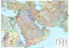
Middle East Wall Map
Political wall map of the Middle East from Gizi Maps with administrative subdivisions of the countries and large amount of topographic information. Coverage extends from Turkey and Egypt to Pakistan and parts of Central Asia. An enlargement covers Israel and the adjoining areas of the neighbouring countries at 1:2, 000, 000.All place names, are in Latin alphabet, with names of selected larger towns also shown in Arabic or Hebrew scripts. Countries are presented in pleasant pastel colours and most include boundaries and names of their administrative provinces.The map shows region
Product Description
Reviews/Comments
Add New
Intelligent Comparison
Archived Product

Middle East Wall Map Stanfords
£13.50
Archived Product

Middle East Road Map Stanfords
£9.99
Archived Product

Middle East Gizi Map Stanfords
£9.99
Archived Product
Middle East Stanfords
£8.50
Archived Product
Middle East Stanfords
£5.99
Archived Product
Middle East Stanfords
£15.19
Archived Product
Middle East Stanfords
£19.99
Archived Product
Middle East Stanfords
£4.99
Vouchers
No voucher codes found.
Do you know a voucher code for this product or supplier? Add it to Insights for others to use.
Do you know a voucher code for this product or supplier? Add it to Insights for others to use.
 Denmark