
 United Kingdom
 France
 Germany
 Netherlands
 Sweden
 USA
USA
 Italy
Italy
 Spain
Spain
More From Contributor


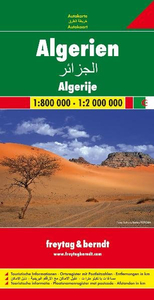
Algeria F&B
Algeria on a large double-sided indexed map from Freytag and Berndt, with the northern part of the country presented at 1:800, 000 and the Saharan interior at 1:2, 000, 000, with a generous overlap between the two sides.Topography is shown by relief shading and spot heights, enhanced by graphics for sand and rock deserts, salt lakes and flats, etc. The map shows numerous seasonal rivers or wadis and wells, many annotated with their names. Oil wells are also marked.The map shows the country’s road network, including cross-desert tracks, railway lines and indicates local airports. Various places of interest are highlighted. Also marked are internal administrative boundaries. All place names are given in Latin alphabet only and, as on most Freytag and Berndt maps, are in large,
easy to read print. The map has latitude and longitude lines at intervals of 1°. Multilingual map legend includes English. The index is in a separate booklet attached to the cover.
easy to read print. The map has latitude and longitude lines at intervals of 1°. Multilingual map legend includes English. The index is in a separate booklet attached to the cover.

Product Description
Reviews/Comments
Add New
Intelligent Comparison
Archived Product
Algeria ITMB Stanfords
£9.99
Archived Product
Bulgaria F&B Stanfords
£10.99
Archived Product
Argentina F&B Stanfords
£10.99
Archived Product
Albania F&B Stanfords
£10.99
Archived Product
Florida F&B Stanfords
£10.99
Archived Product
Austria F&B Stanfords
£10.99
Archived Product
Austria F&B Stanfords
£10.99
Vouchers
No voucher codes found.
Do you know a voucher code for this product or supplier? Add it to Insights for others to use.
Do you know a voucher code for this product or supplier? Add it to Insights for others to use.
 Denmark