
 United Kingdom
 France
 Germany
 Netherlands
 Sweden
 USA
USA
 Italy
Italy
 Spain
Spain
More From Contributor


Austria F&B
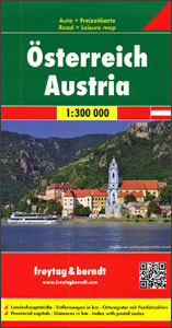
Austria at 1:300, 000 on a large, double-sided, very detailed road map from Freytag & Berndt with very good presentation of the country’s topography, plus an index booklet with town centre street plans of 10 main cities. The map is double-sided, with no overlap between the sides. Coverage includes the German Alps with much of Bavaria, and in the south Italian Tyrol with the Dolomites. Excellent relief shading presents the topography, with plenty of names of individual mountain ranges, valleys, peaks, etc. Finely graded presentation of the road network indicates driving distances on many small local roads, three types of gradient markings, roads closed to motorized traffic or caravans or not suitable for caravans, and toll routes. Scenic roads are highlighted and special
tourist routes are named. Railway lines are shown with stations and various types of mountain transport are marked. Picturesque towns and villages are highlighted and symbols mark locations of various places of interest including campsites and youth hostels. The map has latitude and longitude lines at intervals of 10’. Multilingual map legend includes English.Index booklet, listing all locations with postcodes, also provides city centre street plans of Bregenz, Eisenstadt, Graz, Innsbruck, Klagenfurt, Linz, Salzburg, St. Pölten and Vienna.Please note: some place names on the map are in very small print size.
tourist routes are named. Railway lines are shown with stations and various types of mountain transport are marked. Picturesque towns and villages are highlighted and symbols mark locations of various places of interest including campsites and youth hostels. The map has latitude and longitude lines at intervals of 10’. Multilingual map legend includes English.Index booklet, listing all locations with postcodes, also provides city centre street plans of Bregenz, Eisenstadt, Graz, Innsbruck, Klagenfurt, Linz, Salzburg, St. Pölten and Vienna.Please note: some place names on the map are in very small print size.

Product Description
Reviews/Comments
Add New
Vouchers
No voucher codes found.
Do you know a voucher code for this product or supplier? Add it to Insights for others to use.
Do you know a voucher code for this product or supplier? Add it to Insights for others to use.
 Denmark