
 United Kingdom
 France
 Germany
 Netherlands
 Sweden
 USA
USA
 Italy
Italy
 Spain
Spain
More From Contributor


Bulgaria F&B
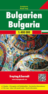
Clear road map displaying the whole country on one side of the sheet.Road detail includes secondary roads and shows intermediate driving distances on most routes. Scenic roads are highlighted and railways are included. General relief is shown by some hill-shading and spot heights for selected peaks. Symbols show motorway filling stations and service areas, antiquities, churches, castles, monuments, telecom towers, airports, border controls, campsites, golf courses and selected sites of interest. All names on the map are given in both Latin script and Cyrillic. Multilingual legend includes English.The index booklet - which also lists post codes - is attached to the map cover. It also includes a plan of central Sofia.

Product Description
Reviews/Comments
Add New
Intelligent Comparison
Archived Product
Bulgaria Stanfords
£4.99
Archived Product
Bulgaria Stanfords
£9.95
Archived Product
Bulgaria Stanfords
£5.99
Archived Product
Bulgaria Stanfords
£9.50
Archived Product
Bulgaria Stanfords
£11.19
Archived Product
Bulgaria Stanfords
£11.99
Archived Product
Bulgaria Stanfords
£4.99
Archived Product

Bulgaria ITMB Stanfords
£9.99
Vouchers
No voucher codes found.
Do you know a voucher code for this product or supplier? Add it to Insights for others to use.
Do you know a voucher code for this product or supplier? Add it to Insights for others to use.
 Denmark