More From Contributor

£13.99
Laminated waterproof edition of a detailed topographic map from the Ordnance Survey Explorer series, covering Kinder Scout, Bleaklow, Black Hill & Ladybower Reservoir (Showing part of the National Park & Pennine Way). Edition A2; Publication date September 2008 About this series: These highly detailed maps show all the administrative boundaries, settlements as small as isolated farms, the road network down to unfenced roads & country tracks, & field boundaries (hedges & drystone walls) which make navigation across the countryside much easier. Steep gradients on roads are indicated. Various landmarks, e.g. powerlines, archaeological sites, windmills, churches & lighthouses are shown & additional graphics indicate natural terrain features such as cliffs, scree, mud & vegetation variations. The contour interval is 5 metres in the lower parts of the country & 10 metres in the uplands, & spot heights are marked. Each map covers an area of 30 x 20km (i.e. approx. 19 x 12 miles), with some double-sided maps covering more, as indicated in the individual descriptions. The maps are fully GPS compatible, with the National Grid shown at 1km intervals & latitude & longitude indicated by margin ticks at 1'. The Explorer series has replaced the earlier, green-cover Pathfinder maps. The Explorer series is now complete & covers all of Engl&, Wales & Scotl&. Some sheets for popular areas like the National Parks are still branded as Outdoor Leisure (OL) maps, but are now included in this series as the cartography is the same as that in the Explorer Maps. The Explorer maps offer a substantial improvement on the Pathfinder series, with greater use of colour, larger area per map, & stronger emphasis on information for ramblers & tourists. This series is ideal for walking & other outdoor pursuits & each map shows a large amount of information for ramblers & tourists. Public rights of way are shown (except in Scotland), together with other routes with public access: National Trails & Recreational Paths, permitted paths & bridleways, & selected cycle routes. Open access land created under the Countryside & Rights of Way Act 2000 is marked. Tourist information

Includes::
caravan & camp sites, Park & Ride locations, recreation/leisure/sport centres, museums, historic buildings, English Heritage & National Trust sites, rural pubs, etc. The map legend is in English only, except for the tourist information content which is also in French & German.

...
Archived Product
£14.99
Builth Wells, Painscastle & Talgarth area on a detailed topographic & GPS compatible map No. 188, waterproof version, from the Ordnance Survey’s 1:25, 000 Explorer series. MOBILE DOWNLOADS: this title & all the other OS Explorer maps include a code for downloading after purchase the digital version onto your smartphone or tablet for viewing on the OS smartphone app.OS EXPLORER SERIES: to see the list of all the titles in the OS Explorer series, both paper & waterproof versions, please click on the series link. The Explorer series, Ordnance Survey’s most detailed maps recommended for anyone enjoying outdoor activities, provides topographic coverage of Great Britain at 1:25, 000 on GPS compatible maps with hiking trails, cycling routes & extensive tourist information. Each printed map is available either on paper or as a waterproof & tear-resistant OS Active Map, as indicated in its title. Britain’s National Parks & other areas of particular tourist interest are presented on often double-sided OL (Outdoor Leisure) maps, whilst most standard format Explorers cover an area of 30 x 20km (approx. 19 x 12 miles). All three versions (paper, waterproof & digital) are the same & provide plenty of recreational & tourist information, indicating the traditional public right of way paths (except in Scotland where different laws apply), including bridleways & byways. National Trails & other long-distance paths are marked, as well as permissive footpaths or bridleways & on-road or traffic-free cycle routes with, where appropriate, their National/ Regional Cycle Network numbers. Boundaries of access land are clearly marked. A wide range of symbols provides additional tourist information, highlighting camping & caravanning sites, information offices & visitors’ centres, parking & picnicking places, country pubs, sport & recreational facilities including cycle hire locations & mountain biking trails, historic buildings & museums, etc. Exceptionally clear presentation of the landscape is provided by contours at 5m or in the uplands at 10m intervals, with additional spot heights plus colouring and/or graphics for different types of woodlands, orchards, heath, marshl&, scree or boulders, & other topographic features. For GPS users the maps have British National Grid lines at 1km intervals, with latitude & longitude given by margin ticks at 1`. Clearly laid out map legend

Includes::
French & German translations for the tourist information symbols.

...
Archived Product
£8.99
Builth Wells, Painscastle & Talgarth area on a detailed topographic & GPS compatible map No. 188, paper version, from the Ordnance Survey’s 1:25, 000 Explorer series.MOBILE DOWNLOADS: this title & all the other OS Explorer maps include a code for downloading after purchase the digital version onto your smartphone or tablet for viewing on the OS smartphone app.OS EXPLORER SERIES: to see the list of all the titles in the OS Explorer series, both paper & waterproof versions, please click on the series link. The Explorer series, Ordnance Survey’s most detailed maps recommended for anyone enjoying outdoor activities, provides topographic coverage of Great Britain at 1:25, 000 on GPS compatible maps with hiking trails, cycling routes & extensive tourist information. Each printed map is available either on paper or as a waterproof & tear-resistant OS Active Map, as indicated in its title. Britain’s National Parks & other areas of particular tourist interest are presented on often double-sided OL (Outdoor Leisure) maps, whilst most standard format Explorers cover an area of 30 x 20km (approx. 19 x 12 miles). All three versions (paper, waterproof & digital) are the same & provide plenty of recreational & tourist information, indicating the traditional public right of way paths (except in Scotland where different laws apply), including bridleways & byways. National Trails & other long-distance paths are marked, as well as permissive footpaths or bridleways & on-road or traffic-free cycle routes with, where appropriate, their National/ Regional Cycle Network numbers. Boundaries of access land are clearly marked. A wide range of symbols provides additional tourist information, highlighting camping & caravanning sites, information offices & visitors’ centres, parking & picnicking places, country pubs, sport & recreational facilities including cycle hire locations & mountain biking trails, historic buildings & museums, etc. Exceptionally clear presentation of the landscape is provided by contours at 5m or in the uplands at 10m intervals, with additional spot heights plus colouring and/or graphics for different types of woodlands, orchards, heath, marshl&, scree or boulders, & other topographic features. For GPS users the maps have British National Grid lines at 1km intervals, with latitude & longitude given by margin ticks at 1`. Clearly laid out map legend

Includes::
French & German translations for the tourist information symbols.

...
Archived Product
£4.99
Bulgaria at 1:600, 000 is an indexed map with additional street plans & enlargements of popular regions on the reverse. The publisher has chosen to concentrate on creating a map which will primarily be of use for a tourist navigating between main points of interest as opposed to stressing more detailed cartography. Motorways, expressways, main & minor roads & some tracks are all clearly marked. Airports & rail lines are easy to see. National borders & crossing points are given. In keeping with the publisher ...
Archived Product
£9.95
Bulgaria at 1:800, 000 from Mair Dumont on an indexed map with special features to aid navigation & route planning, highliting various places worth visiting & providing street plans of central Sofia, Plovdiv, Burgas & Varna. Maps in the Mair Dumont ...
Archived Product
£9.50
Bulgaria on an indexed, waterproof & tear-resistant road map with topographic & tourist information, published by Reise Know-How as part of their highly acclaimed World Mapping Project. The map is double-sided to provide the best balance between a good scale & a convenient size sheet. Road & rail networks are easy to see on a clear base which presents topography by altitude colouring with contours, spot heights & names of mountain ranges. Road network

Includes::
selected unsurfaced local roads, indicates locations of border crossings & shows driving distances on main routes. National parks & protected areas are marked & symbols highlight various places of interest: picturesque towns & villages, campsites, UNESCO world heritage sites, archaeological remains & museums, churches & monasteries of various denominations, viewpoints, beaches, etc. Names of larger towns are given in both scripts
- names of smaller towns & villages & of all the geographical features are in Latin alphabet only. The map has a latitude & longitude grid at intervals of 30


...
Archived Product
£11.19
Bulgaria in the Countries & Regions series from Lonely Planet, market-leading comprehensive guides aimed at independent travellers & serving a large range of international destinations. Frank & informal in style, the guides explore an extensive range of sights, activities, accommodation, restaurants & nightlife & are designed for practical use while travelling on the road. Written & researched by a team of experts, each book is independent in its recommendations & suggestions, often offering individual takes on individual destinations. Widely recognised for their reliability, each Lonely Planet country & region guide has the same layout. Introductory sections profile the destination with individual chapters on particular highlights, getting started, (including when to go) itineraries, history, culture, arts, food & drink & the environment. Each guide is organised geographically by region, with individual sections detailing an extensive range of sights, places of interest, attractions, restaurants, nightlife, accommodation & any local activities. The guides have detailed explanations of historical context where relevant. There is also practical guidance on ...
Archived Product
£11.99
Bulgaria in the Countries, Regions & Cities series from Rough Guides; comprehensively detailed guidebooks specifically designed for independent travellers & serving a range of worldwide destinations. Widely recognised for their free editorial style, Rough Guide authors are allowed to express their personal opinions on a range of subjects. Although sometimes controversial, this editorial stance allows readers to experience more detailed & personal takes on each destination, a feature often more limited in other guidebooks. Cultural & historical nuances are explored in significant depth throughout the text & descriptions on the ambience of individual settings alongside personal recommendations, particularly in cities, are notably prevalent. Each Rough Guide in the Countries, Regions & Cities series has a similar layout. A ...
Archived Product
£4.99
Where Europe encounters the Orient, where cooler climes meet the milder Black Sea coast, Bulgaria reveals unexpected attractions. Bears live in the thickly forested mountains, frescoed monasteries are hidden away in the unspoiled valleys, while the coast, inhabited since Antiquity, roll out a golden carpet of sandy beaches. With its memories of the old Bulgarian kingdom, its cobbled streets & quaint wooden houses, its perfumes & culture, the land exudes an aura of bucolic charm. ...
Archived Product
£7.50
Bulgaria on an indexed road map at 1:750, 000 from the Budapest based Cartographia highlighting the country’s picturesque locations. Additional street plans show central Sofia, Varna & Nesebar. All place names are in Latin alphabet, with names of main towns also given in Cyrillic script. The map clearly shows the country’s topography by relief shading, with plenty of names of mountain ranges & peaks. National parks are highlighted. Road network gives driving distances on main routes. Railway lines, local airports & coastal ferry routes are included. Picturesque locations are highlighted & symbols mark other places of interest and/or facilities, including camsites, mountain refuges, beaches, etc. Latitude & longitude lines are drawn at intervals of 1°. The index is on the reverse side. Map legend

Includes::
English. Also provided are large, clear street plans of central Sofia, Varna & Nesebar, indicating the cities’ main places of interest & selected tourist accommodation.

...
Archived Product

Bulgaria

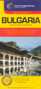
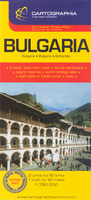
Bulgaria at 1:800, 000 from GeoCenter with cartography from MairDumont on an indexed map highliting various places worth visiting and providing street plans of central Sofia, Plovdiv, Burgas and Varna. Topography is shown by relif shading with plenty of names of local mountain chains, etc. Road network includes small roads and selected dirt tracks, and gives driving distances on many local routes. Scenic roads are highlighted. Railway lines are included and local airports are marked. The map highlights various places worth visiting, both picturesque towns or villages and natural sites such as national parks, mountains, etc.All place names are given only in the Latin alphabet. Latitude and longitude lines are drawn at intervals of 30
RIP - This product is no longer available on our network. It was last seen on 25.09.2019

This page now acts as a permanent archive for this product. Add more information using the comments box below to ensure it can still be found by future generations.

Use our search facility to see if it is available from an alternative contributor.
  • External links may include paid for promotion
  • Availability: Out Of Stock
  • Supplier: Stanfords
  • SKU: 9783829764254
Availability: In Stock
£5.99

Product Description

Bulgaria at 1:800, 000 from Geo Center with cartography from Mair Dumont on an indexed map highliting various places worth visiting & providing street plans of central Sofia, Plovdiv, Burgas & Varna. Topography is shown by relif shading with plenty of names of local mountain chains, etc. Road network

Includes::
small roads & selected dirt tracks, & gives driving distances on many local routes. Scenic roads are highlighted. Railway lines are included & local airports are marked. The map highlights various places worth visiting, both picturesque towns or villages & natural sites such as national parks, mountains, etc. All place names are given only in the Latin alphabet. Latitude & longitude lines are drawn at intervals of 30

Reviews/Comments

Add New

Price History

Vouchers

No voucher codes found.
Do you know a voucher code for this product or supplier? Add it to Insights for others to use.

Facebook

Jargon Buster

Natural - not manmade
Network - A link and communication between things. Often computers or people.
Small - something that takes up less space than normal.
Road - a manmade lane or a path that is used to speed up travel.

Supplier Information

Stanfords
Stanfords was established in 1853 and opened their iconic Covent Garden flagship store in 1901. They have become the top retailer of maps, travel books and accessories in the UK and arguably offer the largest selection of maps and travel books worldwide. Famous names such as Captain Robert Falcon Scott, Ranulph Fiennes and Michael Palin have purchased from Stanfords. They now have a shop in Bristol and both stores together with other venues operate a calendar of events including talks, book signings and exhibitions. As a specialist map retailer, the map selection is comprehensive and includes road maps, street maps and walking maps from worldwide destinations, as well as a selection of world atlases and wall maps. Books include travel guides and travel literature. Stanfords also stock globes, from miniatures made of blue marble to magnificent floor-standing globes. The website features a selection of interesting articles on travel topics.
Page Updated: 2023-11-12 20:15:36

Community Generated Product Tags

Oh No! The productWIKI community hasn't generated any tags for this product yet!
Menu