
 United Kingdom
 France
 Germany
 Netherlands
 Sweden
 USA
USA
 Italy
Italy
 Spain
Spain
More From Contributor


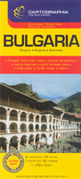
Bulgaria
Bulgaria on an indexed road map at 1:750, 000 from the Budapest based Cartographia highlighting the country’s picturesque locations. Additional street plans show central Sofia, Varna and Nesebar. All place names are in Latin alphabet, with names of main towns also given in Cyrillic script.The map clearly shows the country’s topography by relief shading, with plenty of names of mountain ranges and peaks. National parks are highlighted. Road network gives driving distances on main routes. Railway lines, local airports and coastal ferry routes are included. Picturesque locations are highlighted and symbols mark other places of interest and/or facilities, including camsites, mountain refuges, beaches, etc. Latitude and longitude lines are drawn at intervals of 1°. The index is on
the reverse side. Map legend includes English.Also provided are large, clear street plans of central Sofia, Varna and Nesebar, indicating the cities’ main places of interest and selected tourist accommodation.
the reverse side. Map legend includes English.Also provided are large, clear street plans of central Sofia, Varna and Nesebar, indicating the cities’ main places of interest and selected tourist accommodation.

Product Description
Reviews/Comments
Add New
Vouchers
No voucher codes found.
Do you know a voucher code for this product or supplier? Add it to Insights for others to use.
Do you know a voucher code for this product or supplier? Add it to Insights for others to use.
 Denmark