More From Contributor
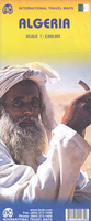
£5.99
The Michelin National road map of Algeria & Tunisia at 1:1, 000, 000 scale is ideal for trip & route planning. The map gives comprehensive coverage of national road networks showing all major motorways, dual carriageways, national & regional main roads & some local roads. Also shows unsurfaced roads & tracks & major footpaths. Road obstacles & dangers including steep slopes, seasonally impassable routes, height restrictions, one-way roads, tolls, narrow bridges & high passes are indicated. Clear, easy-to read cartography shows roads in reds, yellows & white with black outlines. Major topography is indicated with relief shading. Woodland & forest is marked with green shading, desert in yellow & some indication of salt flats & marshl&. Towns & cities are marked with symbols only on the main map, but regional enlargements (see below) show built-up urban areas in salmon pink highlighting. Airports, ferries, railways, bridges & level crossings are also marked. National & administrative divisions are shown, as are administrative seats & state capitals. Plenty of detailed tourist information is given: Accommodation & practical facilities (hotels, resorts, fuel & repair services where attached to a hotel), sport & leisure facilities (e.g. golf courses, winder sports & spas) & sights. Sights include kasbahs, rural markets, areas of outstanding tourist interest, scenic driving routes, viewpoints & panoramas, forts, ruins & other historical locations.

Includes::
markings for other features including palm groves, national parks, pipelines & natural resource extraction. Town plans & regional enlargements:- Oran & surrounding area at 1:300, 000- Algiers & Kabylie region to B

...
Archived Product
£5.99
The Michelin National road map of Algeria & Tunisia at 1:1, 000, 000 scale is ideal for trip & route planning. The map gives comprehensive coverage of national road networks showing all major motorways, dual carriageways, national & regional main roads & some local roads. Also shows unsurfaced roads & tracks & major footpaths. Road obstacles & dangers including steep slopes, seasonally impassable routes, height restrictions, one-way roads, tolls, narrow bridges & high passes are indicated. Clear, easy-to read cartography shows roads in reds, yellows & white with black outlines. Major topography is indicated with relief shading. Woodland & forest is marked with green shading, desert in yellow & some indication of salt flats & marshl&. Towns & cities are marked with symbols only on the main map, but regional enlargements (see below) show built-up urban areas in salmon pink highlighting. Airports, ferries, railways, bridges & level crossings are also marked. National & administrative divisions are shown, as are administrative seats & state capitals. Plenty of detailed tourist information is given: Accommodation & practical facilities (hotels, resorts, fuel & repair services where attached to a hotel), sport & leisure facilities (e.g. golf courses, winder sports & spas) & sights. Sights include kasbahs, rural markets, areas of outstanding tourist interest, scenic driving routes, viewpoints & panoramas, forts, ruins & other historical locations.

Includes::
markings for other features including palm groves, national parks, pipelines & natural resource extraction. Town plans & regional enlargements:- Oran & surrounding area at 1:300, 000- Algiers & Kabylie region to Béja a at 1:300, 000- Tunis & surrounding area at 1:500, 000- Tlemcen & surrounding area at 1:500, 000- Plan of central Tunis at 1:35, 000- Algiers & metropolitan area at 1:50, 000

...
Archived Product
£10.50
Algeria & Tunisia on an indexed, waterproof & tear-resistant road map with topographic & tourist information, published by Reise Know-How as part of their highly acclaimed World Mapping Project. The map is double-sided to provide the best balance between a good scale & a convenient size sheet. Road & rail networks are easy to see on a clear base which shows the area’s topography by altitude colouring with contours, spot heights, mountain passes, & names of mountain ranges. The map also shows swamps, salt lakes & seasonal rivers. Internal administrative boundaries are shown with names of the provinces. Road network

Includes::
unsurfaced roads & seasonal tracks & indicates locations of fuel supplies. A wide range of symbols highlight various places of interest, including national parks & protected areas, oases & water wells, archaeological remains, cave paintings, viewpoints, mosques & churches, selected hotels, beaches & diving sites, etc. Oil or gas wells & pipelines are also marked. The map has a latitude & longitude grid at intervals of 1° & an index of place names. Map legend is in English, French & German. Major towns & cities are marked in both English & Arabic text.*” World Mapping Project”* is an extensive series of maps at varying scales, aiming to provide coverage of countries & regions worldwide using clear, well presented cartography with both topographic & tourist information.

...
Archived Product
£10.99
Algeria on a large double-sided indexed map from Freytag & Berndt, with the northern part of the country presented at 1:800, 000 & the Saharan interior at 1:2, 000, 000, with a generous overlap between the two sides. Topography is shown by relief shading & spot heights, enhanced by graphics for sand & rock deserts, salt lakes & flats, etc. The map shows numerous seasonal rivers or wadis & wells, many annotated with their names. Oil wells are also marked. The map shows the country’s road network, including cross-desert tracks, railway lines & indicates local airports. Various places of interest are highlighted. Also marked are internal administrative boundaries. All place names are given in Latin alphabet only &, as on most Freytag & Berndt maps, are in large, easy to read print. The map has latitude & longitude lines at intervals of 1°. Multilingual map legend

Includes::
English. The index is in a separate booklet attached to the cover.

...
Archived Product
£13.50
Algeria Geographical Wall Map at 1:2, 500, 000 from Gizi Map, size 98 x 87cm (38”x 34” approx.), with bright altitude colouring vividly presenting the country’s topography. Names of larger towns, provinces & selected topographic features are also shown in the Arabic alphabet; all other place names are in the Latin alphabet. Where appropriate, alternative versions of place names are also provided (Oran/ Wahran, etc). Bold altitude colouring with plenty of spot heights & names of mountain ranges, deserts, etc, provides a vivid picture of the country’s topography. Graphics show stone or sand deserts, salt flats, swaps & seasonal wadis, with symbols indicating oasis & water wells. Road network

Includes::
desert tracks & shows distances on main & on many secondary routes. Railway lines are

Includes::
& local airports are marked; the map also shows locations of oil or gas wells & the pipe lines, plus administrative boundaries of the provinces. Symbols mark various places of interest, including campsites, beaches, UNESCO World Heritage sites, rock paintings, archaeological remains, etc. Coverage

Includes::
all but the southernmost part of Morocco (without South Sahara), all of Tunisia, & the western part of Libya just beyond Tripoli. Latitude & longitude lines are drawn at 1º intervals. The index is next to the map. Map legend

Includes::
English & Arabic.PLEASE NOTE: this title is also available as a folded map, plus in an alternative road edition where the altitude colouring has been replaced by relief shading.


...
Archived Product
£13.50
Algeria Raod Edition Wall Map at 1:2, 500, 000, size 98x 87cm (38”x 34” approx), from Gizi Map, with relief shading used to present the country’s topography. Names of larger towns, provinces & selected topographic features are also shown in the Arabic alphabet; all other place names are in the Latin alphabet. Where appropriate, alternative versions of place names are also provided (Oran/ Wahran, etc). Relief shading with plenty of spot heights & names of mountain ranges, deserts, etc, is used to show the country’s topography. Graphics indicate stone or sand deserts, salt flats, swaps & seasonal wadis, with symbols marking oasis & water wells. Road network

Includes::
desert tracks & shows distances on main & on many secondary routes. Railway lines are

Includes::
& local airports are marked; the map also shows locations of oil or gas wells & the pipe lines, plus administrative boundaries of the provinces. Symbols mark various places of interest, including campsites, beaches, UNESCO World Heritage sites, rock paintings, archaeological remains, etc. Coverage

Includes::
all but the southernmost part of Morocco (without South Sahara), all of Tunisia, & the western part of Libya just beyond Tripoli. Latitude & longitude lines are drawn at 1º intervals. The index is next to the map. Map legend

Includes::
English & Arabic.PLEASE NOTE: this title is also available in a folded format, plus in an alternative geographical edition where topography is shown by bright altitude colouring.


...
Archived Product
£14.95
Map No. G-1B in the TPC series: military topographic survey mapping covering the world's land masses & significant islands at 1:500, 000. The maps are useful as general topographical coverage where nothing else is available, although they are designed primarily as flying charts for military aircraft. TPC stands for Tactical Pilotage Chart. Relief is portrayed by a combination of contours (basic interval 500ft, intermediate contours shown where appropriate), elevation tinting & relief shading, plus spot heights. Towns, villages, major roads, railways & airports are shown but please note that many of the smaller settlements are not named & the road information is not necessarily up to date, as compilation & revision dates vary. Some air navigation information also appears on the map, such as radio beacons & restricted flying zones. Each TPC chart has both UTM & latitude/longitude grids overprinted on it, with additional margin ticks. IMPORTANT
- PLEASE NOTE: The series is gradually being withdrawn from sale to the general public & some sheets may no longer be available when ordered by us. Due to the nature of the map projection assembling these sheets to make a larger map is not recommended. in addition, colours used for relief are not constant throughout the series. In some areas of central Africa & South America the maps have blank spaces, reflecting localized deficiencies or inconsistencies in the survey data.
...
Archived Product
£14.95
Map No. H-1B in the TPC series: military topographic survey mapping covering the world's land masses & significant islands at 1:500, 000. The maps are useful as general topographical coverage where nothing else is available, although they are designed primarily as flying charts for military aircraft. TPC stands for Tactical Pilotage Chart. Relief is portrayed by a combination of contours (basic interval 500ft, intermediate contours shown where appropriate), elevation tinting & relief shading, plus spot heights. Towns, villages, major roads, railways & airports are shown but please note that many of the smaller settlements are not named & the road information is not necessarily up to date, as compilation & revision dates vary. Some air navigation information also appears on the map, such as radio beacons & restricted flying zones. Each TPC chart has both UTM & latitude/longitude grids overprinted on it, with additional margin ticks. IMPORTANT
- PLEASE NOTE: The series is gradually being withdrawn from sale to the general public & some sheets may no longer be available when ordered by us. Due to the nature of the map projection assembling these sheets to make a larger map is not recommended. in addition, colours used for relief are not constant throughout the series. In some areas of central Africa & South America the maps have blank spaces, reflecting localized deficiencies or inconsistencies in the survey data.
...
Archived Product
£14.95
Map No. H-2A in the TPC series: military topographic survey mapping covering the world's land masses & significant islands at 1:500, 000. The maps are useful as general topographical coverage where nothing else is available, although they are designed primarily as flying charts for military aircraft. TPC stands for Tactical Pilotage Chart. Relief is portrayed by a combination of contours (basic interval 500ft, intermediate contours shown where appropriate), elevation tinting & relief shading, plus spot heights. Towns, villages, major roads, railways & airports are shown but please note that many of the smaller settlements are not named & the road information is not necessarily up to date, as compilation & revision dates vary. Some air navigation information also appears on the map, such as radio beacons & restricted flying zones. Each TPC chart has both UTM & latitude/longitude grids overprinted on it, with additional margin ticks. IMPORTANT
- PLEASE NOTE: The series is gradually being withdrawn from sale to the general public & some sheets may no longer be available when ordered by us. Due to the nature of the map projection assembling these sheets to make a larger map is not recommended. in addition, colours used for relief are not constant throughout the series. In some areas of central Africa & South America the maps have blank spaces, reflecting localized deficiencies or inconsistencies in the survey data.
...
Archived Product
£14.95
Map No. G-1C in the TPC series: military topographic survey mapping covering the world's land masses & significant islands at 1:500, 000. The maps are useful as general topographical coverage where nothing else is available, although they are designed primarily as flying charts for military aircraft. TPC stands for Tactical Pilotage Chart. Relief is portrayed by a combination of contours (basic interval 500ft, intermediate contours shown where appropriate), elevation tinting & relief shading, plus spot heights. Towns, villages, major roads, railways & airports are shown but please note that many of the smaller settlements are not named & the road information is not necessarily up to date, as compilation & revision dates vary. Some air navigation information also appears on the map, such as radio beacons & restricted flying zones. Each TPC chart has both UTM & latitude/longitude grids overprinted on it, with additional margin ticks. IMPORTANT
- PLEASE NOTE: The series is gradually being withdrawn from sale to the general public & some sheets may no longer be available when ordered by us. Due to the nature of the map projection assembling these sheets to make a larger map is not recommended. in addition, colours used for relief are not constant throughout the series. In some areas of central Africa & South America the maps have blank spaces, reflecting localized deficiencies or inconsistencies in the survey data.
...
Archived Product

Algeria ITMB

Algeria at 1:2, 000, 000 on an indexed, double-sided map from ITMB including a street plan of central Alger highlighting places of interest and selected accommodation.The map divides the country east/west, with a good overlap between the sides. Altitude colouring shows the topography with graphics indicating deserts, swamps, salt flats, water wells, oasis and seasonal rivers. Numerous spot heights are marked, particularly in the southern part of the country, with names of mountain ranges and other geographical features. Road network includes desert tracks, gives distances on main routes, and indicates border crossings. Railway lines are included and local airports are marked. Symbols mark locations of various places of interest including towns with tourist accommodation,
campsites, rock art paintings and archaeological sites, etc. The map also shows gas and oil extraction sites and pipelines, as well as internal administrative boundaries with names of the provinces. Coverage in the west includes most of Morocco, extending south beyond Agadir. All place names are shown transliterated only. Latitude and longitude line are drawn at intervals of 1°. The map is indexed and included a street plan of central Alger annotated with places of interest.
RIP - This product is no longer available on our network. It was last seen on 25.09.2019

This page now acts as a permanent archive for this product. Add more information using the comments box below to ensure it can still be found by future generations.

Use our search facility to see if it is available from an alternative contributor.
  • External links may include paid for promotion
  • Availability: Out Of Stock
  • Supplier: Stanfords
  • SKU: 9781553411062
Availability: In Stock
£9.99

Product Description

Algeria at 1:2, 000, 000 on an indexed, double-sided map from ITMB including a street plan of central Alger highlighting places of interest & selected accommodation. The map divides the country east/west, with a good overlap between the sides. Altitude colouring shows the topography with graphics indicating deserts, swamps, salt flats, water wells, oasis & seasonal rivers. Numerous spot heights are marked, particularly in the southern part of the country, with names of mountain ranges & other geographical features. Road network

Includes::
desert tracks, gives distances on main routes, & indicates border crossings. Railway lines are included & local airports are marked. Symbols mark locations of various places of interest including towns with tourist accommodation, campsites, rock art paintings & archaeological sites, etc. The map also shows gas & oil extraction sites & pipelines, as well as internal administrative boundaries with names of the provinces. Coverage in the west

Includes::
most of Morocco, extending south beyond Agadir. All place names are shown transliterated only. Latitude & longitude line are drawn at intervals of 1°. The map is indexed & included a street plan of central Alger annotated with places of interest.

Reviews/Comments

Add New

Price History

Vouchers

No voucher codes found.
Do you know a voucher code for this product or supplier? Add it to Insights for others to use.

Facebook

Jargon Buster

Oil - A hydrophobic liquid with high carbon and hydrogen content. Has many variations including; cooking oils, petrochemical oils, essential oils.
water - A chemical substance. Chemical formula H2O.
Graphics - A general term for visual aspects of an item/display
Network - A link and communication between things. Often computers or people.
Road - a manmade lane or a path that is used to speed up travel.
Altitude - Something that can be quite high in relation to sea or ground level.
Accommodation - A room in which someone can live in, for example in a hotel

Supplier Information

Stanfords
Stanfords was established in 1853 and opened their iconic Covent Garden flagship store in 1901. They have become the top retailer of maps, travel books and accessories in the UK and arguably offer the largest selection of maps and travel books worldwide. Famous names such as Captain Robert Falcon Scott, Ranulph Fiennes and Michael Palin have purchased from Stanfords. They now have a shop in Bristol and both stores together with other venues operate a calendar of events including talks, book signings and exhibitions. As a specialist map retailer, the map selection is comprehensive and includes road maps, street maps and walking maps from worldwide destinations, as well as a selection of world atlases and wall maps. Books include travel guides and travel literature. Stanfords also stock globes, from miniatures made of blue marble to magnificent floor-standing globes. The website features a selection of interesting articles on travel topics.
Page Updated: 2023-11-12 20:15:36

Community Generated Product Tags

Oh No! The productWIKI community hasn't generated any tags for this product yet!
Menu