
 United Kingdom
 France
 Germany
 Netherlands
 Sweden
 USA
USA
 Italy
Italy
 Spain
Spain
More From Contributor


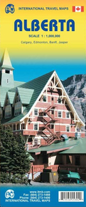
Alberta ITMB
Alberta at 1:1, 000, 000 on a double-sided, indexed map from the Vancouver-based ITMB, with topography presented by altitude colouring rather than by just relief shading, with street plan of central Edmonton and Calgary, plus of Banff and Jasper resorts. Coverage includes the whole of the Banff and the Jasper National Parks.Road and rail networks are presented on a clear base with altitude colouring, spot heights and names of mountain ranges. Numerous national or regional parks and nature reserves are marked. Symbols highlight various places of interest, sport and recreational facilities, native reserves, etc, including parks with camping facilities and campgrounds. The map has a latitude and longitude grid at intervals of 1º; each side has a separate index of localities.Street
plans shows the main traffic routes in central Calgary and Edmonton, plus in the mountain resorts of Banff and Jasper, indicating locations of various hotels, selected restaurants, and other places of interest.
plans shows the main traffic routes in central Calgary and Edmonton, plus in the mountain resorts of Banff and Jasper, indicating locations of various hotels, selected restaurants, and other places of interest.

Product Description
Reviews/Comments
Add New
Vouchers
No voucher codes found.
Do you know a voucher code for this product or supplier? Add it to Insights for others to use.
Do you know a voucher code for this product or supplier? Add it to Insights for others to use.
 Denmark