More From Contributor
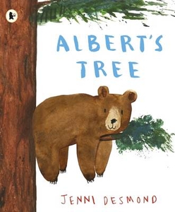
£9.99
Alberta at 1:1, 000, 000 on a double-sided, indexed map from the Vancouver-based ITMB, with topography presented by altitude colouring rather than by just relief shading, with street plan of central Edmonton & Calgary, plus of Banff & Jasper resorts. Coverage

Includes::
the whole of the Banff & the Jasper National Parks. Road & rail networks are presented on a clear base with altitude colouring, spot heights & names of mountain ranges. Numerous national or regional parks & nature reserves are marked. Symbols highlight various places of interest, sport & recreational facilities, native reserves, etc, including parks with camping facilities & campgrounds. The map has a latitude & longitude grid at intervals of 1º; each side has a separate index of localities. Street plans shows the main traffic routes in central Calgary & Edmonton, plus in the mountain resorts of Banff & Jasper, indicating locations of various hotels, selected restaurants, & other places of interest.

...
Archived Product
£12.99
Pocket road atlas of Alberta presenting the whole province at 1:1, 325, 000, with numerous enlargement showing in more detail most visited areas, including Banff, Jasper, Canmore, Calgary, Edmonton, etc. The index

Includes::
a listing of the province’s national & provincial parks. Road network indicates loose surface & unimproved roads, showing driving distances on main & on many local roads. National & provincial parks & other protected areas are prominently indicated by colouring, with numerous rivers & lakes also named. Symbols highlight locations of campgrounds, travel information centres, recreational areas, etc. The maps have no geographical coordinates. Street plans at scales around 1:50, 000 cover Banff, Jasper, Brooks, Airdrie, Camrose, Canmore, Drumheller, Fort Saskatchewan, Fort Mc Murray, Grande Prairie, Okotoks, Leduc, Lethbridge, Lloydminster, Medicin Hat, & Wetaskiwin; maps at 1:250, 000 show Calgary, Edmonton & the Red Deer area, with downtown Calgary & Edmonton also presented on more detailed plans at 1:25, 000. To see the list of the currently available provincial or regional road atlases from the Map Art / Canadian Cartographics Corporation / JDM Géo publishing group, please click on the series link.

...
Archived Product
£7.50
Indexed road map of Southern Alberta, covering an area from the US border to the Saskatchewan River Crossing in the Banff National Park in the north-west & the border of the Special Area No.4 in the north-east. Coverage extends across the border with BC beyond Cranbrook & Invermere to include Yoho NP, Kootenay NP & the Purcell Wilderness Conservancy Provincial Park. Street plans at 1:25, 000 cover central Calgary, Drumheller, Medicine Hat, Lethbridge, & Strathmore. Also included are enlargements of the environs of Calgary & Medicine Hat, an index for the main map, plus distance table. The map is one of the titles in a series of indexed road maps of the Canadian provinces & regions from the country ...
Archived Product
£12.99
A little boy & his grandfather embark on a quest to find the old man`s missing birthday in Diana Rosie`s debut novel, Alberto`s Lost Birthday. Alberto is an old man. But he doesn`t know how old
- he remembers nothing before his arrival at an orphanage during the Spanish civil war. He rarely thinks about his missing childhood, but when seven-year-old Tino discovers his grandfather has never had a birthday party, never blown out candles on a birthday cake, never received a single birthday present, he`s determined things should change. & so the two set out to find Alberto`s birthday. Their search for the old man`s memories takes them deep into the heart of Spain
- a country that has pledged to forget its painful past. As stories of courage, cruelty & love unfold, Alberto realises that he has lost more than a birthday. He has lost a part of himself. But with his grandson`s help, he might just find it again.

...
Archived Product
£12.99
Topographic survey of France at 1:25, 000 in IGN`s excellent TOP25 / Série Bleue series. All the maps are GPS compatible, with a 1km UTM grid plus latitude & longitude lines at 5’ intervals. Contours are at 5m intervals except for mountainous areas where the maps have contours at 10m intervals, vividly enhanced by hill shading & graphics for rocky terrain. Colouring with graphics indicates different types of vegetation or land use (deciduous or coniferous forests, moors, orchards, vineyards, etc). PLEASE NOTE: coverage of France at this scale is currently being revised – the format & the presentation of each title are indicated by the letters at the end of its Sheet Reference number (e.g. 0416ET, 3531ETR, 1923SB, etc.)MAPS WITH FULL TOURIST OVERPRINT & AN ENGLISH MAP LEGEND: all TOP25 maps & the SB editions of Série Bleue have an overprint highlighting waymarked walking trails including long-distance GR routes &, where appropriate, ski routes. Symbols indicate campsites, gîtes d’etape, refuges, equestrian centres & other recreational facilities or sites, tourist information centres, cultural heritage, etc. Towns & locations of particular interest are highlighted.- ET or OT = single-sided TOP25 map covering approx. 29x 21 km / 18x 13 miles.- ETR or OTR = waterproof & tear resistant TOP25 map covering the same area as the corresponding ET or OT number, but double-sided, printed on a smaller size sheet with a good overlap between the sides.- SB = Série Bleue map with full tourist overprint; these maps, first introduced in summer 2014, each cover approx. 29x 24km / 18x 15 miles.SÉRIE BLEUE maps with numbers ending in E (Est) or O (Ouest): most editions now indicate the GR routes, but do not show any other tourist information. Map legend is in French only. Each map covers approx. 14x 20km / 9x 12 miles. ...
Archived Product
£11.50
Topographic survey of France at 1:25, 000 in IGN`s excellent TOP25 / Série Bleue series. All the maps are GPS compatible, with a 1km UTM grid plus latitude & longitude lines at 5’ intervals. Contours are at 5m intervals except for mountainous areas where the maps have contours at 10m intervals, vividly enhanced by hill shading & graphics for rocky terrain. Colouring with graphics indicates different types of vegetation or land use (deciduous or coniferous forests, moors, orchards, vineyards, etc). PLEASE NOTE: coverage of France at this scale is currently being revised – the format & the presentation of each title are indicated by the letters at the end of its Sheet Reference number (e.g. 0416ET, 3531ETR, 1923SB, etc.)MAPS WITH FULL TOURIST OVERPRINT & AN ENGLISH MAP LEGEND: all TOP25 maps & the SB editions of Série Bleue have an overprint highlighting waymarked walking trails including long-distance GR routes &, where appropriate, ski routes. Symbols indicate campsites, gîtes d’etape, refuges, equestrian centres & other recreational facilities or sites, tourist information centres, cultural heritage, etc. Towns & locations of particular interest are highlighted.- ET or OT = single-sided TOP25 map covering approx. 29x 21 km / 18x 13 miles.- ETR or OTR = waterproof & tear resistant TOP25 map covering the same area as the corresponding ET or OT number, but double-sided, printed on a smaller size sheet with a good overlap between the sides.- SB = Série Bleue map with full tourist overprint; these maps, first introduced in summer 2014, each cover approx. 29x 24km / 18x 15 miles.SÉRIE BLEUE maps with numbers ending in E (Est) or O (Ouest): most editions now indicate the GR routes, but do not show any other tourist information. Map legend is in French only. Each map covers approx. 14x 20km / 9x 12 miles. ...
Archived Product
£8.99
Spain in the 1930s. Nine-year-old Albi runs messages for people. He likes to help out, especially now that his country is at war with itself. When his brother & papa become involved with the militia & the Guardia (nationalists) begin reprisals, Albi struggles to make sense of who is on the right side. His family are under siege from outside & held captive by secrets within the home. Albi must sometimes close his ears & his eyes if he is to survive. The secrets he keeps haunt him until his 88th year, long after the end of a war that has shaped generations of Spaniards. ...
Archived Product
£6.99
Street plan of the Albi
- St-Juéry area, part of an extensive series covering French cities & towns from Blay-Foldex, the country’s
...
Archived Product
£12.99
Topographic survey of France at 1:25, 000 in IGN`s excellent TOP25 / Série Bleue series. All the maps are GPS compatible, with a 1km UTM grid plus latitude & longitude lines at 5’ intervals. Contours are at 5m intervals except for mountainous areas where the maps have contours at 10m intervals, vividly enhanced by hill shading & graphics for rocky terrain. Colouring with graphics indicates different types of vegetation or land use (deciduous or coniferous forests, moors, orchards, vineyards, etc). PLEASE NOTE: coverage of France at this scale is currently being revised – the format & the presentation of each title are indicated by the letters at the end of its Sheet Reference number (e.g. 0416ET, 3531ETR, 1923SB, etc.)MAPS WITH FULL TOURIST OVERPRINT & AN ENGLISH MAP LEGEND: all TOP25 maps & the SB editions of Série Bleue have an overprint highlighting waymarked walking trails including long-distance GR routes &, where appropriate, ski routes. Symbols indicate campsites, gîtes d’etape, refuges, equestrian centres & other recreational facilities or sites, tourist information centres, cultural heritage, etc. Towns & locations of particular interest are highlighted.- ET or OT = single-sided TOP25 map covering approx. 29x 21 km / 18x 13 miles.- ETR or OTR = waterproof & tear resistant TOP25 map covering the same area as the corresponding ET or OT number, but double-sided, printed on a smaller size sheet with a good overlap between the sides.- SB = Série Bleue map with full tourist overprint; these maps, first introduced in summer 2014, each cover approx. 29x 24km / 18x 15 miles.SÉRIE BLEUE maps with numbers ending in E (Est) or O (Ouest): most editions now indicate the GR routes, but do not show any other tourist information. Map legend is in French only. Each map covers approx. 14x 20km / 9x 12 miles. ...
Archived Product
£8.99
Map No. 161, Albi
- Montauban at 1:100, 000, part of the TOP100 series from the Institut Géographique National (IGN). These
...
Archived Product

Albert`s Tree

A picture book about making new friends from the award-winning Jenni Desmond.Waa! Waa! Waa! Albert`s favourite tree won`t stop crying. What can be the matter? How can the bear cheer up his old friend? A funny and charming picture book about making friends in the most unexpected places from the award-winning Jenni Desmond.
RIP - This product is no longer available on our network. It was last seen on 25.09.2019

This page now acts as a permanent archive for this product. Add more information using the comments box below to ensure it can still be found by future generations.

Use our search facility to see if it is available from an alternative contributor.
  • External links may include paid for promotion
  • Availability: Out Of Stock
  • Supplier: Stanfords
  • SKU: 9781406362497
Availability: In Stock
£6.99

Product Description

A picture book about making new friends from the award-winning Jenni Desmond. Waa! Waa! Waa! Albert`s favourite tree won`t stop crying. What can be the matter? How can the bear cheer up his old friend? A funny & charming picture book about making friends in the most unexpected places from the award-winning Jenni Desmond.

Reviews/Comments

Add New

Intelligent Comparison

Oooops!
We couldn't find anything!
Perhaps this product's unique.... Or perhaps we are still looking for comparisons!
Click to bump this page and we'll hurry up.

Price History

Vouchers

No voucher codes found.
Do you know a voucher code for this product or supplier? Add it to Insights for others to use.

Facebook

Jargon Buster

Friends - A close associate or a popular US based sitcom about a group of friends

Supplier Information

Stanfords
Stanfords was established in 1853 and opened their iconic Covent Garden flagship store in 1901. They have become the top retailer of maps, travel books and accessories in the UK and arguably offer the largest selection of maps and travel books worldwide. Famous names such as Captain Robert Falcon Scott, Ranulph Fiennes and Michael Palin have purchased from Stanfords. They now have a shop in Bristol and both stores together with other venues operate a calendar of events including talks, book signings and exhibitions. As a specialist map retailer, the map selection is comprehensive and includes road maps, street maps and walking maps from worldwide destinations, as well as a selection of world atlases and wall maps. Books include travel guides and travel literature. Stanfords also stock globes, from miniatures made of blue marble to magnificent floor-standing globes. The website features a selection of interesting articles on travel topics.
Page Updated: 2023-11-12 20:15:36

Community Generated Product Tags

Oh No! The productWIKI community hasn't generated any tags for this product yet!
Menu