More From Contributor
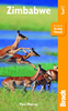
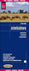
£15.95
Trekking in the Zillertal Alps guide from Cicerone Press with two multi-day, hut-to-hut hiking routes presented with detailed descriptions & accompanied by sketch maps & profiles, plus a hut directory, etc. The two routes covered by the guide are:- Zillertal Rucksack Route (Berliner Hohenweg): a circular tour from Mayrhofen which links eight huts without crossing glaciers or difficult passes & gives ample opportunity for scaling nearby peaks.- Zillertal South Tyrol Tour traversing the whole range on the Italian side of the border & linking to the Rucksack route to make a larger circular tour. Both routes are presented on overall route profiles & have detailed stage-by-stage descriptions accompanied by sketch maps. Publishers’ recommendations for more detailed mapping: at 1:25, 000 Alpenverein sheets 35/1 & 35/2, or at 1:50, 000 Kompass No. 37 or Freytag & Berndt No. 152, are all available from Stanfords’ website. The guide

Includes::
30-page hut directory providing for each hut not only full contact details but also a description with its history, etc. An introductory chapter gives general information about the region & tips for hikers. Four appendices include route summary tables, a glossary, etc.

...
Archived Product
£11.99
Want to travel in a rocket? Search for a grumpy dragon? Make your very own monster? Visit a higgledy-piggledy farm? Well, hop into Zim Zam Zoom
- for fun & adventures galore! Colours, animals, space, music, fairytale fireworks...! Here is a collection of poems especially written for performance. With delightful illustrations by a talented new illustrator, this is a brilliant introduction to poetry for young children.
...
Archived Product
£13.99
Zimbabwe on a double-side road map from the South African publishers International Motoring Productions with GPS waypoints for selected towns or settlements. The map, one of a series of similar maps covering countries & selected regions of southern Africa, has rather simple cartography with somewhat basic elevation tinting & occasional spot heights. Main rivers (not named) & lakes are marked & protected areas are highlighted. Roads are classified as national, major, minor, & 4WD tracks & show driving distances on main routes & locations of fuel stations. Border crossings to neighbouring countries indicate opening times. Symbols mark various places of interest. Some towns or settlements & important road junctions are annotated with GPS waypoints, although far fewer than on the publishers’ similar maps of other southern African countries. A basic street plan shows central Harare naming mains streets. The map, published in 2005, also

Includes::
an “ Accommodation & Activities Legend” with an extensive list of symbols for various types of accommodation, sport & recreational facilities, etc, none of which appear on the map itself.

...
Archived Product
£17.99
Zimbabwe is a country both blessed & cursed. Arriving to work at the British Embassy in Zimbabwe, Philip Barclay found a temperate paradise & a sophisticated & charming population. But during a three-year stay in what used to be Africa's finest country, he saw it ruined by violence & grotesque economic mismanagement. Philip Barclay was at the centre of the tumultuous events of 2008. Zimbabwe's people voted against Robert Mugabe, but their desire for change was denied as vicious squads of indoctrinated youths loyal to the ageing dictator launched a campaign of murder, rape, & destruction. In the wake of such terror, the country's economy & public services collapsed, leading to widespread poverty & epidemics of diseases that Zimbabwe had not seen in living memory. This electrifying account records the violent excesses of a hated clique prepared to do anything to cling to power. It asks why the world stood by & watched as Zimbabwe burned & questions whether power-sharing between Robert Mugabe & Morgan Tsvangirai offers the way forward which the country needs. An honest account of a diplomat's confrontation with a brutal dictatorship, Zimbabwe is also a personal story of the resilience
- despite their daily experience of despair & death
- of Zimbabwe's people.

...
Archived Product
£9.50
Indexed, waterproof & tear-resistant road map Zimbabwe with topographic & tourist information, published by Reise Know-How as part of their highly acclaimed World Mapping Project. The map is double-sided to provide the best balance between a good scale & a convenient size sheet. Topography is indicated by altitude colouring with numerous spot heights, names of mountain ranges & passes, salt pans, marshes & swamps. In northern Matabeleland in the Hwange National Park numerous pans are marked. Road information

Includes::
seasonal tracks & indicates intermediate driving distances on main & secondary roads. Locations of petrol stations, veterinary cordon fences & border crossings are also marked. Other transport details include railways & local airfields. Internal administrative boundaries are shown with names of the provinces. National parks & protected areas are marked & symbols highlight various places of interest: UNESCO world heritage sites, archaeological remains, viewpoints, hot springs & wells, caves & rock paintings, selected accommodation including campsites & lodges, medical facilities, etc. The map has a latitude & longitude grid at intervals of 1

...
Archived Product
£16.99
This new third edition of Bradt`s Zimbabwe remains the most authoritative & trusted guide available, written in an engaging & entertaining style by an expert author who has been visitng Zimbabwe annually for nearly 30 years & now spends six months of each year there. In this new thoroughly revised edition, Paul Murray brings a particular focus for those wanting to travel independently as well as visitors on organised tours. Game viewing in some of Africa`s greatest national parks is a rewarding experience & this guide offers in-depth information on the facilities, advice on itinerary planning as well as how to select a safari. Accommodation is covered with up-to-date information on everything from luxury safari camps to budget stays for younger travellers who arrive overl&, heading for the fast flowing waters of the Zambezi gorge. There are also details of en-route accommodation not found in other guides following a complete countrywide review of all destinations that are key to independent travellers, making this by far the most up-to-date guidebook to Zimbabwe on the market. As political tension relaxes, wildlife enthusiasts & curious tourists are returning to Zimbabwe, a country which not so long ago was southern Africa`s premier tourist destination, with some of the finest national parks in Africa, stunning landscapes & an abundance of wildlife. The mighty Zambezi River offers adventure holidays, & Victoria Falls will leave visitors breathless, while the range of birdlife draws enthusiasts year-round. ...
Archived Product
£14.99
Zimbabwe in the Handbooks series from Footprint; comprehensive & leading guides designed & written for independent travellers who enjoy exploring off the beaten track. Footprint guides have an established reputation, built up since 1921, for catering for more adventurous & individual travellers. An unrestrictive editorial style also gives authors the freedom to capture & explore local cultures, sights & areas that are often not covered in other guides. Widely recognised for their reliability & independent writing style, Footprint guides all have the same layout. Introductory sections introduce the reader to the destination, with chapters on planning on your trip & essentials, including practical information & guidance on subjects such as when & where to go, itineraries, sport & activities, arts, getting there & around, eating & drinks, sleeping & a dedicated section on the anticipated carbon footprint involved in travelling to the destination. Each guide is organised geographically by region or country, with individual sections having a particular focus on an extensive range of sights & places of interest. Further, there are also details of accommodation, nightlife, restaurants & any notable local activities. Information boxes throughout the text give readers an insight into local customs, stories & sights of particular interest.A ‘ Background’ section explores the history, economy, government, education, culture, people, land & environment of the destination in significant depth. There is also a ‘ Footnotes’ chapter with a basic language guide for travellers & information about the author. A useful distance chart tailored to the destination is also included in the inside back cover. * Please note:* the series is gradually being revised, reverting to its previous style of ” Handbooks”, published in a hardback format. ...
Archived Product
£10.99
Zimbabwe at 1:1, 200, 000 on an indexed road map from Map Studio, with good presentation of the country’s topography, GPS waypoints for important road junctions, locations of filling stations, plus a large street plan of central Harare, The main map presents the network of roads & tracks, marking locations of borders crossings & petrol stations, & giving driving distances on main routes. Numerous GPS waypoints are provided for larger settlements or important road junctions. The map also shows the railway lines, local airfields, & internal administrative boundaries with names of the provinces. Symbols indicate locations with different types of tourist accommodation including campsites, medical facilities, & various points of interest. Topography is presented by altitude colouring & national parks/safari areas are highlighted. In addition of GPS waypoints, latitude & longitude lines are drawn at 1ºn intervals. The index is next to the map.A large inset shows central Harare highlighting main traffic routes & selected places of interest including embassies, etc. ...
Archived Product
£7.99
Zimbabwe’s national parks & tourist areas presented on separate panels, annotated with GPS coordinates for important locations, entry gates, accommodation facilities, viewpoints, etc. Scales which vary according to the size of the park are clearly marked on each panel.A small overview map of Zimbabwe shows the location of each area covered by an individual panel which presents the road network to & within each park, indicating tarred & unsurfaced roads & 4x 4 seasonal tracks. Driving distances are shown on most routes & entry gates are marked, indicating where appropriate permit requirements. Where useful, important road junctions are annotated with their GPS waypoints & the panels also have latitude & longitude lines. Symbols show locations of petrol stations, hotels/lodges/chalets, campsites, animal viewing points, & other places of interest. The map covers: Zambezi NP with Victoria Falls, Mana Pools NP, Hwange NP, Gonarezhou NP, Kazuma Pan NP, Hurungwe & Charara Safari areas, Matusadona NP, Lake Kyle Recreational Park, Chizarira NP, Matobo NP, & Nyanga NP. All information is in English. ...
Archived Product
£11.50
Indexed, waterproof & tear-resistant road map Zimbabwe at 1:800, 000 with topographic & tourist information, published by Reise Know-How as part of their highly acclaimed World Mapping Project. The map is double-sided to provide the best balance between a good scale & a convenient size sheet. Topography is indicated by altitude colouring with numerous spot heights, names of mountain ranges & passes, salt pans, marshes & swamps. In northern Matabeleland in the Hwange National Park numerous pans are marked. Road information

Includes::
seasonal tracks & indicates intermediate driving distances on main & secondary roads. Locations of petrol stations, veterinary cordon fences & border crossings are also marked. Other transport details include railways & local airfields. Internal administrative boundaries are shown with names of the provinces. National parks & protected areas are marked & symbols highlight various places of interest: UNESCO world heritage sites, archaeological remains, viewpoints, hot springs & wells, caves & rock paintings, selected accommodation including campsites & lodges, medical facilities, etc. The map has a latitude & longitude grid at intervals of 1° & an index of localities which

Includes::
a list of national parks & game reserves. Map legend

Includes::
English.” World Mapping Project” is an extensive series of maps at varying scales, aiming to provide coverage of countries & regions worldwide using clear, well presented cartography with both topographic & tourist information.


...
Archived Product

Zimbabwe

As political tension relaxes, wildlife enthusiasts and curious tourists are returning to Zimbabwe. With some of the finest national parks in Africa, the country is blessed with stunning landscapes and an abundance of wildlife. The mighty Zambezi River offers adventure holidays, and Victoria Falls will leave visitors breathless, while the range of birdlife draws enthusiasts year-round. Game viewing in some of Africa's greatest national parks is a rewarding experience and this guide offers in-depth information on the facilities, advice on itinerary planning as well as how to select a safari. Accommodation is covered with up-to-date information on everything from luxury safari camps to budget stays for younger travellers who arrive overland, heading for the fast flowing waters of the
Zambezi gorge.
RIP - This product is no longer available on our network. It was last seen on 25.09.2019

This page now acts as a permanent archive for this product. Add more information using the comments box below to ensure it can still be found by future generations.

Use our search facility to see if it is available from an alternative contributor.
  • Availability: Out Of Stock
  • Supplier: Stanfords
  • SKU: 9781841624600
Availability: In Stock
£16.99

Product Description

As political tension relaxes, wildlife enthusiasts & curious tourists are returning to Zimbabwe. With some of the finest national parks in Africa, the country is blessed with stunning landscapes & an abundance of wildlife. The mighty Zambezi River offers adventure holidays, & Victoria Falls will leave visitors breathless, while the range of birdlife draws enthusiasts year-round. Game viewing in some of Africa's greatest national parks is a rewarding experience & this guide offers in-depth information on the facilities, advice on itinerary planning as well as how to select a safari. Accommodation is covered with up-to-date information on everything from luxury safari camps to budget stays for younger travellers who arrive overl&, heading for the fast flowing waters of the Zambezi gorge.

Reviews/Comments

Add New

Intelligent Comparison

Oooops!
We couldn't find anything!
Perhaps this product's unique.... Or perhaps we are still looking for comparisons!
Click to bump this page and we'll hurry up.

Price History

Vouchers

No voucher codes found.
Do you know a voucher code for this product or supplier? Add it to Insights for others to use.

Facebook

Jargon Buster

Tension - A force that is stretching an object
Tension - Also known as stress, a situation where a human can not cope with emotional or physical threats
Date - A day on a calendar
Date - A social activity whith a current or potential partner
Year - The time it takes the planet earth to orbit the sun. This takes around 365.25 days.
Adventure - an undertaking of an exciting challenge or experience.
Rewarding - Achieving and doing something good.
Luxury - An exquisite way of living, an sometimes come at a higher price.
Accommodation - A room in which someone can live in, for example in a hotel
Experience - To gain further knowledge by practising.
Year - 365 days (366 days in a leap year), the time taken for planet earth to make one full revolution around the sun.

Supplier Information

Stanfords
Stanfords was established in 1853 and opened their iconic Covent Garden flagship store in 1901. They have become the top retailer of maps, travel books and accessories in the UK and arguably offer the largest selection of maps and travel books worldwide. Famous names such as Captain Robert Falcon Scott, Ranulph Fiennes and Michael Palin have purchased from Stanfords. They now have a shop in Bristol and both stores together with other venues operate a calendar of events including talks, book signings and exhibitions. As a specialist map retailer, the map selection is comprehensive and includes road maps, street maps and walking maps from worldwide destinations, as well as a selection of world atlases and wall maps. Books include travel guides and travel literature. Stanfords also stock globes, from miniatures made of blue marble to magnificent floor-standing globes. The website features a selection of interesting articles on travel topics.
Page Updated: 2023-11-12 20:15:36

Community Generated Product Tags

Oh No! The productWIKI community hasn't generated any tags for this product yet!
Menu